Skip to search
Skip to main content
Digital Commonwealth
Sign Up / Log In
Search for
Search
Search
Search
Basic
Advanced
Explore
Map
Collections
Institutions
Formats
For Educators
Primary Source Sets
Lesson Plans
Using Primary Sources
Searching Digital Commonwealth
For Institutions
Join Digital Commonwealth
Conferences, Trainings, & Events
How to Contribute Collections
Digitization Services
Board & Committees
Frequently Asked Questions
About
About Digital Commonwealth
News & Announcements
Copyright & Terms of Use
Harmful Content Statement
Partners
API
Contact Us
American Antiquarian Society
American Revolutionary War-Era Maps (Collection of Distinction)
/
American Antiquarian Society Collection
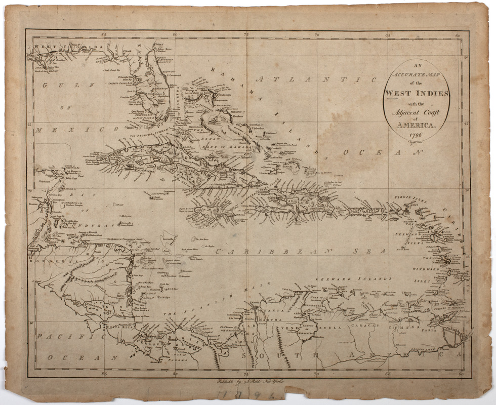
An Accurate map of the West Indies with the adjacent coast of America. 1796
An Accurate map of the West Indies with the adjacent coast of America. 1796
×
Item Information
Title:
An Accurate map of the West Indies with the adjacent coast of America. 1796
Title (uniform):
American atlas
Description:
Subject: Map of the West Indies, with parts of Florida, Central America and South America shown.
Publisher:
Reid, John, 1764?-1828
Name on Item:
D. Martin sculpt.
Date:
[1796]
Format:
Maps/Atlases
Location:
American Antiquarian Society
Collection (local):
American Antiquarian Society Collection
Subjects:
West Indies--Maps
Places:
West Indies
Extent:
1 map : engraving ; 36 x 46 cm., on sheet 41 x 50 cm.
Permalink:
https://ark.digitalcommonwealth.org/ark:/50959/z603vh18n
Terms of Use:
Public Domain/No known restrictions on use. Contact host institution to download image.
Contact host institution for more information.
Publisher:
[New York] : Publish'd by J. Reid New York.
Scale:
Scale [ca. 1:8,500,000]
Language:
English
Referenced by:
http://catalog.mwa.org/vwebv/holdingsInfo?bibId=483254
Notes:
Relief shown pictorially.
From The American Atlas, New York : Published by John Reid, 1796 (Evans 31078).
Notes (date):
This date is inferred.
show more...
View MODS XML
More Like This
An accurate map of the West Indies, : containing the Bahama & ...
An accurate map of the West Indies
An Accurate map of the West Indies, with the adjacent coast
An accurate map of the West Indies with the adjacent coast of America
Find More Like This >>
Tools
Share
Facebook
Pinterest
X
Reddit
Tumblr
Email
Copy link
Add to Folder
Questions/Comments
Cite This Item
IIIF Manifest