Skip to search
Skip to main content
Digital Commonwealth
Sign Up / Log In
Search for
Search
Search
Search
Basic
Advanced
Explore
Map
Collections
Institutions
Formats
For Educators
Primary Source Sets
Lesson Plans
Using Primary Sources
Searching Digital Commonwealth
For Institutions
Join Digital Commonwealth
Conferences, Trainings, & Events
How to Contribute Collections
Digitization Services
Board & Committees
Frequently Asked Questions
About
About Digital Commonwealth
News & Announcements
Copyright & Terms of Use
Harmful Content Statement
Partners
API
Contact Us
American Antiquarian Society
American Revolutionary War-Era Maps (Collection of Distinction)
/
American Antiquarian Society Collection
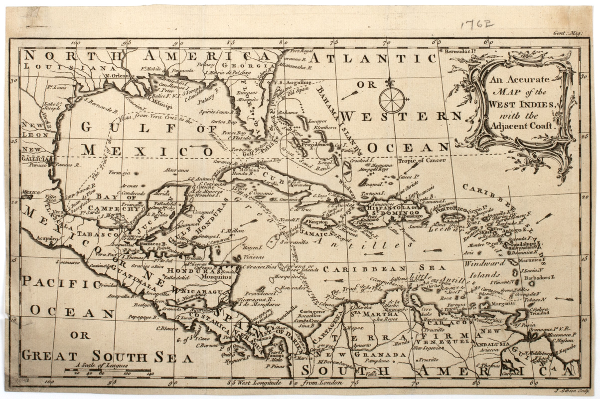
An Accurate map of the West Indies, with the adjacent coast
An Accurate map of the West Indies, with the adjacent coast
×
Item Information
Title:
An Accurate map of the West Indies, with the adjacent coast
Title (uniform):
Gentleman's magazine (London, England)
Description:
Subject: Map of the West Indies and Caribbean including parts of the southeastern United States, Mexico and the northern part of South America.
Former owner:
Walker, John
Engraver:
Gibson, J. (John), active 1750-1792
Name on Item:
J. Gibson sculp.
Date:
[1762]
Format:
Maps/Atlases
Location:
American Antiquarian Society
Collection (local):
American Antiquarian Society Collection
Subjects:
West Indies--Maps
Caribbean Area--Maps
Places:
West Indies
Caribbean Sea
Extent:
1 map : engraving ; 18 x 30 cm., on sheet 20 x 30 cm.
Permalink:
https://ark.digitalcommonwealth.org/ark:/50959/z603vh17c
Terms of Use:
Public Domain/No known restrictions on use. Contact host institution to download image.
Contact host institution for more information.
Publisher:
London : [s.n.]
Scale:
Scale [ca. 1:20,000,000]
Language:
English
Referenced by:
http://catalog.mwa.org/vwebv/holdingsInfo?bibId=483146
Notes:
Relief shown pictorially.
"Gent. mag."
From Gentleman's magazine, London, February, 1762.
Notes (date):
This date is inferred.
show more...
View MODS XML
More Like This
An accurate map of the West Indies, : containing the Bahama & ...
Les Isles Antilles et le Golfe du Méxique
A new and correct map of the American islands, now called the West ...
West Indies
Find More Like This >>
Tools
Share
Facebook
Pinterest
X
Reddit
Tumblr
Email
Copy link
Add to Folder
Questions/Comments
Cite This Item
IIIF Manifest