Skip to search
Skip to main content
Digital Commonwealth
Sign Up / Log In
Search for
Search
Search
Search
Basic
Advanced
Explore
Map
Collections
Institutions
Formats
For Educators
Primary Source Sets
Lesson Plans
Using Primary Sources
Searching Digital Commonwealth
For Institutions
Join Digital Commonwealth
Conferences, Trainings, & Events
How to Contribute Collections
Digitization Services
Board & Committees
Frequently Asked Questions
About
About Digital Commonwealth
News & Announcements
Copyright & Terms of Use
Harmful Content Statement
Partners
API
Contact Us
American Antiquarian Society
American Revolutionary War-Era Maps (Collection of Distinction)
/
American Antiquarian Society Collection
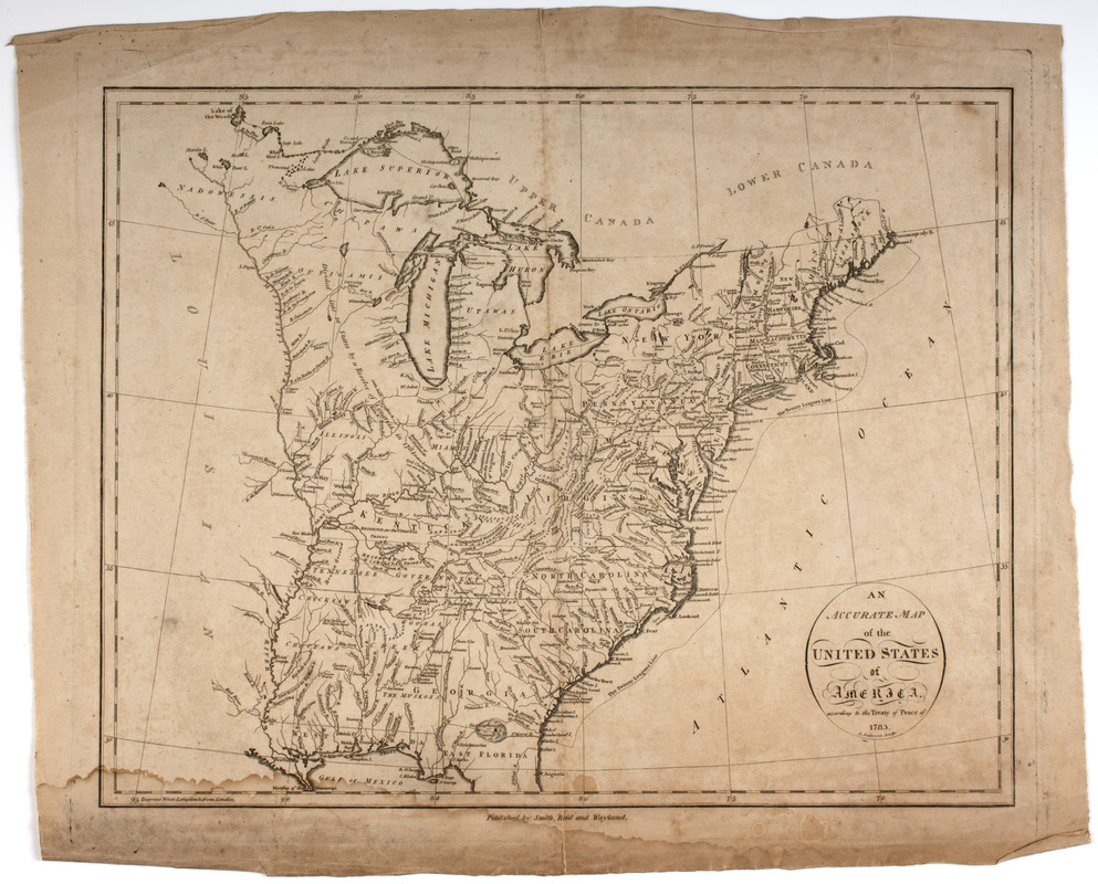
An Accurate map of the United States of America. : According to the Treaty of Peace of 1783
An Accurate map of the United States of America.
×
Item Information
Title:
An Accurate map of the United States of America. : According to the Treaty of Peace of 1783
Title (uniform):
American atlas
Description:
Subject: Map of the land of the United States after the peace treaty of 1783. Shows land extending west to the Mississippi River and south to Florida. Also shows the lands belonging to the different Native American nations.
Engraver:
Anderson, Alexander, 1775-1870
Publisher:
Smith, Reid & Wayland
Name on Item:
A. Anderson sculp.
Date:
[1796]
Format:
Maps/Atlases
Location:
American Antiquarian Society
Collection (local):
American Antiquarian Society Collection
Subjects:
Indians of North America--Land tenure
United States--Foreign relations--1775-1783
United States--Maps
Places:
Extent:
1 map ; 36 x 46 cm., on sheet 43 x 52.5 cm.
Permalink:
https://ark.digitalcommonwealth.org/ark:/50959/z603vg930
Terms of Use:
Public Domain/No known restrictions on use. Contact host institution to download image.
Contact host institution for more information.
Publisher:
[New York] : Published by Smith, Reid and Wayland.
Scale:
Scale [ca. 1:6,500,000]
Language:
English
Referenced by:
http://catalog.mwa.org/vwebv/holdingsInfo?bibId=475952
Notes:
Prime meridian: London.
Relief shown pictorially.
From The American Atlas, New York : Published by John Reid, 1796 (Evans 31078).
Notes (date):
This date is inferred.
show more...
View MODS XML
More Like This
The British governments in Nth. America : laid down agreeable to ...
A correct map of the United States of North America. : Including ...
America Septentrionalis : a Domino d'Anville in Galliis edita nune ...
Amplissima regionis Mississipi : seu provinciae Ludoviciana à ...
Find More Like This >>
Tools
Share
Facebook
Pinterest
X
Reddit
Tumblr
Email
Copy link
Add to Folder
Questions/Comments
Cite This Item
IIIF Manifest