Skip to search
Skip to main content
Digital Commonwealth
Sign Up / Log In
Search for
Search
Search
Search
Basic
Advanced
Explore
Map
Collections
Institutions
Formats
For Educators
Primary Source Sets
Lesson Plans
Using Primary Sources
Searching Digital Commonwealth
For Institutions
Join Digital Commonwealth
Conferences, Trainings, & Events
How to Contribute Collections
Digitization Services
Board & Committees
Frequently Asked Questions
About
About Digital Commonwealth
News & Announcements
Copyright & Terms of Use
Harmful Content Statement
Partners
API
Contact Us
Boston Public Library
Norman B. Leventhal Map Center Collection
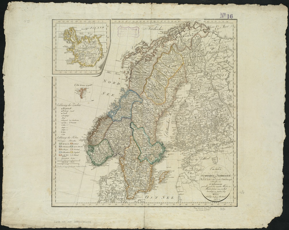
Charte von Schweden und Norwegen
Charte von Schweden und Norwegen
×
Item Information
Title:
Charte von Schweden und Norwegen
Creator:
Reinecke, J. C. M. (Johann Christoph Matthias), 1770-1818
Name on Item:
nach den besten astronomischen Ortsbestimmungen entworfen von I.C.M. Reinecke ; jetzt aber nach dem neuesten Frieden zu Friedrichshamm vom 17ten Sept. berichtigt im October 1809.
Date:
1809
Format:
Maps/Atlases
Location:
Boston Public Library
Norman B. Leventhal Map Center
Collection (local):
Norman B. Leventhal Map Center Collection
Subjects:
Scandinavia--Maps
Sweden--Maps
Norway--Maps
Places:
Scandinavia
(area)
Norway
Sweden
Extent:
1 map : outline col. ; 49 x 48 cm.
Permalink:
https://ark.digitalcommonwealth.org/ark:/50959/xg94j1612
Terms of Use:
No known copyright restrictions.
No known restrictions on use.
Publisher:
Weimar : Verlag des Geogr. Instituts
Scale:
Scale ca. 1:3,700,000.
Language:
German
Notes:
Relief shown by hachures.
Insets: Iceland and the Faroe Islands.
Identifier:
06_01_006494
Call #:
G6910 1809 .R45
Barcode:
39999059026094
show more...
View MODS XML
More Like This
Schweden und Norwegen
Bennett's tourists' route map of Norway
Norway, from the best authorities
Baltic Basin
Find More Like This >>
Tools
Share
Facebook
Pinterest
X
Reddit
Tumblr
Email
Copy link
Add to Folder
Questions/Comments
Cite This Item
IIIF Manifest
Downloads
Primary (full resolution, uncompressed)
(TIF, 212 MB)
Large (full resolution)
(JPEG, 17.8 MB)
Medium
(JPEG, 303 KB)
GeoTIFF (georeferenced)
(TIF, 228 MB)