Skip to search
Skip to main content
Digital Commonwealth
Sign Up / Log In
Search for
Search
Search
Search
Basic
Advanced
Explore
Map
Collections
Institutions
Formats
For Educators
Primary Source Sets
Lesson Plans
Using Primary Sources
Searching Digital Commonwealth
For Institutions
Join Digital Commonwealth
Conferences, Trainings, & Events
How to Contribute Collections
Digitization Services
Board & Committees
Frequently Asked Questions
About
About Digital Commonwealth
News & Announcements
Copyright & Terms of Use
Harmful Content Statement
Partners
API
Contact Us
Boston Public Library
Norman B. Leventhal Map Center Collection
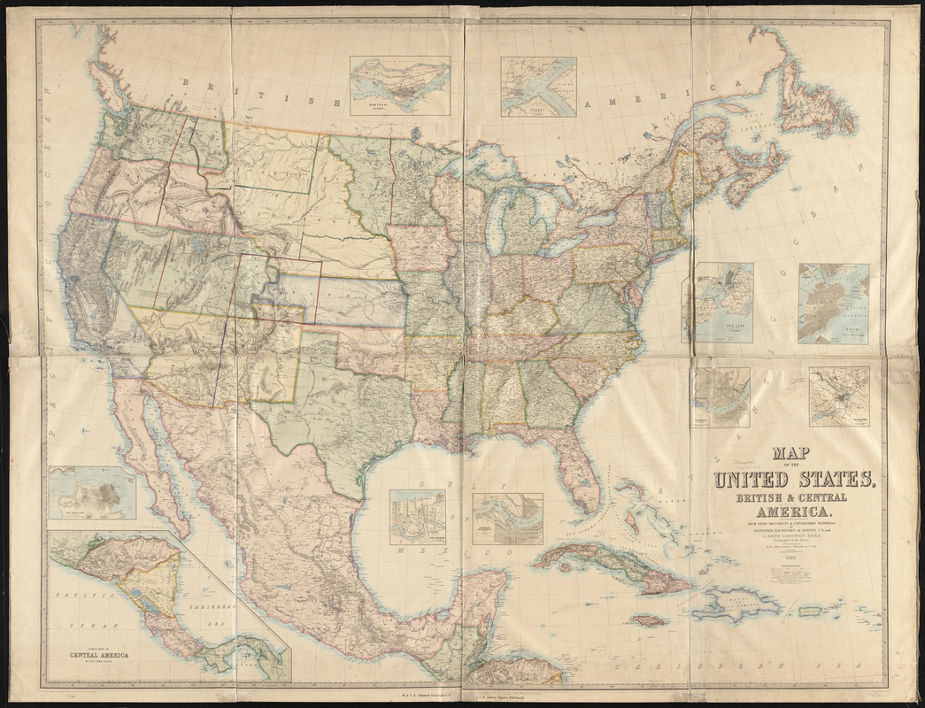
Map of the United States, British & Central America : from state documents & unpublished materials
Map of the United States, British & Central America
×
Item Information
Title:
Map of the United States, British & Central America : from state documents & unpublished materials
Creator:
Rogers, Henry D. (Henry Darwin), 1808-1866
Contributor:
Johnston, Keith, 1844-1879
Contributor:
W. & A.K. Johnston Limited
Name on Item:
by H.D. Rogers... and A. Keith Johnston ; engraved by W & A.K. Johnston
Date:
1857
Format:
Maps/Atlases
Location:
Boston Public Library
Norman B. Leventhal Map Center
Collection (local):
Norman B. Leventhal Map Center Collection
Subjects:
United States--Maps
Mexico--Maps
Central America--Maps
Places:
Mesoamerica
(area)
Mexico
Extent:
1 map : col., dissected and mounted on canvas ; 136 x 172 cm.
Permalink:
https://ark.digitalcommonwealth.org/ark:/50959/x059cd37q
Terms of Use:
No known copyright restrictions.
No known restrictions on use.
Publisher:
Edinburgh : W. & A.K. Johnston
Scale:
Scale 1:3,540,000
Language:
English
Notes:
Relief shown by hachures.
Insets: Montreal -- Quebec -- New York -- Boston -- Philadelphia -- Cincinnati -- Louisville, Jeffersonville -- New Orleans -- San Francisco -- Continuation of Central America on the same scale.
Identifier:
06_01_008411
Call #:
G3700 1857 .R64
Barcode:
39999065653659
show more...
View MODS XML
More Like This
Map of the United States of America, Mexico, Central America, and ...
Map of the United States of America, the British provinces, ...
Map of the United States of America, the British Provinces, ...
The countries of the Caribbean : including Mexico, Central ...
Find More Like This >>
Tools
Share
Facebook
Pinterest
X
Reddit
Tumblr
Email
Copy link
Add to Folder
Questions/Comments
Cite This Item
IIIF Manifest
Downloads
Primary (full resolution, uncompressed)
(TIF, 751 MB)
Large (full resolution)
(JPEG, 63.1 MB)
Medium
(JPEG, 362 KB)
GeoTIFF (georeferenced)
(TIF, 931 MB)