Skip to search
Skip to main content
Digital Commonwealth
Sign Up / Log In
Search for
Search
Search
Search
Basic
Advanced
Explore
Map
Collections
Institutions
Formats
For Educators
Primary Source Sets
Lesson Plans
Using Primary Sources
Searching Digital Commonwealth
For Institutions
Join Digital Commonwealth
Conferences, Trainings, & Events
How to Contribute Collections
Digitization Services
Board & Committees
Frequently Asked Questions
About
About Digital Commonwealth
News & Announcements
Copyright & Terms of Use
Harmful Content Statement
Partners
API
Contact Us
Boston Public Library
Norman B. Leventhal Map Center Collection
/
Urban Maps (Collection of Distinction)
/
Boston and New England Maps (Collection of Distinction)
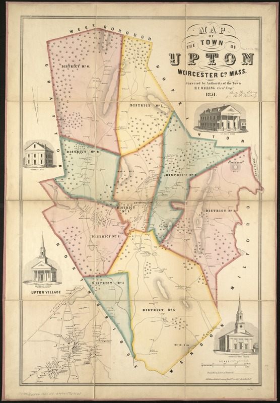
Map of the town of Upton, Worcester Co., Mass : surveyed by authority of the town
Map of the town of Upton, Worcester Co., Mass
×
Item Information
Title:
Map of the town of Upton, Worcester Co., Mass : surveyed by authority of the town
Creator:
Walling, Henry Francis, 1825-1888
Name on Item:
by H.F. Walling.
Date:
1851
Format:
Maps/Atlases
Location:
Boston Public Library
Norman B. Leventhal Map Center
Collection (local):
Norman B. Leventhal Map Center Collection
Subjects:
Real property--Massachusetts--Upton (Town)--Maps
Landowners--Massachusetts--Upton (Town)--Maps
Upton (Mass. : Town)--Maps
Places:
Worcester (county)
>
Upton
Extent:
1 map ; 82 x 53 cm.
Permalink:
https://ark.digitalcommonwealth.org/ark:/50959/x059cc06h
Terms of Use:
No known copyright restrictions.
No known restrictions on use.
Publisher:
Phil[adelphi]a : A. Kollner's Lithy. & Printing Establmt
Scale:
Scale [ca. 1:16,200].
Language:
English
Notes:
Relief shown by hachures.
Shows buildings with names of property owners and town districts.
Inset: Upton Village.
Includes 4 views of town buildings.
Identifier:
06_01_005470
Call #:
G3764.U6G46 1851 .W3
Barcode:
39999059014538
show more...
View MODS XML
More Like This
The 100th anniversary map of Abraham Lincoln's visit to ...
1630 shoreline
1879. Progress map of the U.S. Geographical Surveys west of the ...
1903 Map of Salem and surrounding places
Find More Like This >>
Tools
Share
Facebook
Pinterest
X
Reddit
Tumblr
Email
Copy link
Add to Folder
Questions/Comments
Cite This Item
IIIF Manifest
Downloads
Primary (full resolution, uncompressed)
(TIF, 176 MB)
Large (full resolution)
(JPEG, 14.8 MB)
Medium
(JPEG, 172 KB)