Skip to search
Skip to main content
Digital Commonwealth
Sign Up / Log In
Search for
Search
Search
Search
Basic
Advanced
Explore
Map
Collections
Institutions
Formats
For Educators
Primary Source Sets
Lesson Plans
Using Primary Sources
Searching Digital Commonwealth
For Institutions
Join Digital Commonwealth
Conferences, Trainings, & Events
How to Contribute Collections
Digitization Services
Board & Committees
Frequently Asked Questions
About
About Digital Commonwealth
News & Announcements
Copyright & Terms of Use
Harmful Content Statement
Partners
API
Contact Us
Boston Public Library
Norman B. Leventhal Map Center Collection
/
Urban Maps (Collection of Distinction)
/
Boston and New England Maps (Collection of Distinction)
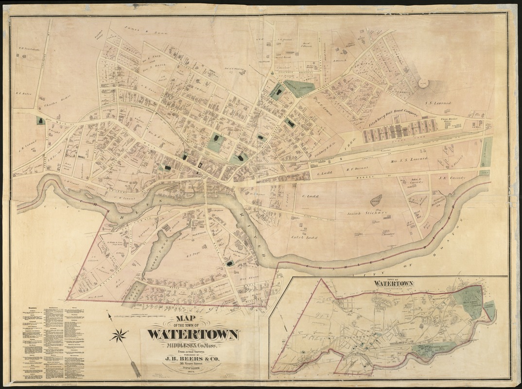
Map of the town of Watertown : Middlesex Co., Mass., from actual surveys
Map of the town of Watertown
×
Item Information
Title:
Map of the town of Watertown : Middlesex Co., Mass., from actual surveys
Creator:
J.B. Beers & Co
Name on Item:
engraved by L.E. Neuman.
Date:
1874
Format:
Maps/Atlases
Location:
Boston Public Library
Norman B. Leventhal Map Center
Collection (local):
Norman B. Leventhal Map Center Collection
Subjects:
Real property--Massachusetts--Watertown--Maps
Landowners--Massachusetts--Watertown--Maps
Watertown (Mass.)--Maps
Places:
Middlesex (county)
>
Watertown
Extent:
1 map : col. ; 110 x 153 cm.
Permalink:
https://ark.digitalcommonwealth.org/ark:/50959/x059c954r
Terms of Use:
No known copyright restrictions.
No known restrictions on use.
Publisher:
New York : J.B. Beers & Co.
Scale:
Scale 1:1,800.
Language:
English
Notes:
Oriented with north toward the upper left.
Inset: Town of Watertown, Scale 800 feet to the inch [shows entire town at scale 1:9,600].
Subscribers are listed in lower left corner.
Identifier:
06_01_005394
Call #:
G3764.W3G46 1874 .B4x
Barcode:
39999059013720
show more...
View MODS XML
More Like This
Atlas of the towns of Watertown, Belmont, Arlington and Lexington, ...
Historical map of Watertown, 1630-1930
Map of the cemetery of Mount Auburn, Boston
Mount Auburn, avenues and paths
Find More Like This >>
Tools
Share
Facebook
Pinterest
X
Reddit
Tumblr
Email
Copy link
Add to Folder
Questions/Comments
Cite This Item
IIIF Manifest
Downloads
Primary (full resolution, uncompressed)
(TIF, 276 MB)
Large (full resolution)
(JPEG, 23.1 MB)
Medium
(JPEG, 307 KB)
GeoTIFF (georeferenced)
(TIF, 408 MB)