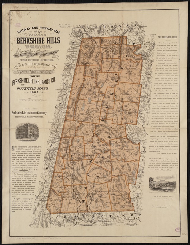
Railway and highway map of the famous Berkshire Hills region, showing also villages and points of interest : from official records and other information
Railway and highway map of the famous Berkshire Hills region, showing also villages and points of interest
Item Information
Title:
Railway and highway map of the famous Berkshire Hills region, showing also villages and points of interest : from official records and other information
Description:
The Berkshire Hills of western Massachusetts are home to a number of Trustees properties. Farms, meadows, ponds, hills, mountains and historic homes make up the fourteen sites in the Berkshires, several of which are depicted on this 1883 map designed to promote tourism in the region. The mountainous topography of the area is highlighted in this map to emphasize the numerous recreational activities available to visitors. Monument Mountain in Great Barrington – one of The Trustees earliest properties – was a popular destination for nature lovers in the 19th century because of its majestic views of the southern Berkshires.
Relief shown by hachures and spot heights.
Differs from other 1883 ed. in that it does not show main roads, school houses, cemeteries, churches, and railroads stations in red and does not include a key in upper right corner.
Includes text and ill.
Notes (exhibitions):
Exhibited: "From the Sea to the Mountains: The Trustees 125th Anniversary" organized by the Norman B. Leventhal Map Center at the Boston Public Library, 2016.