Skip to search
Skip to main content
Digital Commonwealth
Sign Up / Log In
Search for
Search
Search
Search
Basic
Advanced
Explore
Map
Collections
Institutions
Formats
For Educators
Primary Source Sets
Lesson Plans
Using Primary Sources
Searching Digital Commonwealth
For Institutions
Join Digital Commonwealth
Conferences, Trainings, & Events
How to Contribute Collections
Digitization Services
Board & Committees
Frequently Asked Questions
About
About Digital Commonwealth
News & Announcements
Copyright & Terms of Use
Harmful Content Statement
Partners
API
Contact Us
Boston Public Library
Norman B. Leventhal Map Center Collection
/
Boston and New England Maps (Collection of Distinction)
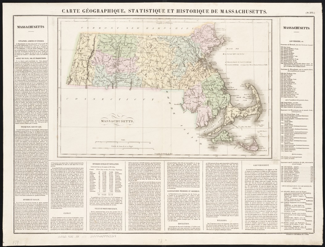
Carte géographique, statistique et historique de Massachusetts
Carte géographique, statistique et historique de Massachusetts
×
Item Information
Title:
Carte géographique, statistique et historique de Massachusetts
Creator:
Buchon, J. A. C. (Jean Alexandre C.), 1791-1846
Date:
[1825]
Format:
Maps/Atlases
Location:
Boston Public Library
Norman B. Leventhal Map Center
Collection (local):
Norman B. Leventhal Map Center Collection
Subjects:
Massachusetts--Maps
Massachusetts--History--Maps
Massachusetts--Statistics--Maps
Places:
Massachusetts
Extent:
1 map : col. ; 29 x 44 cm, on sheet 55 x 69 cm. + appendix
Permalink:
https://ark.digitalcommonwealth.org/ark:/50959/wd376560h
Terms of Use:
No known copyright restrictions.
No known restrictions on use.
Publisher:
Paris : J. Carez
Scale:
Scale [ca. 1:697,000]
Language:
French
Notes:
Appears in Buchon's Atlas géographique, hisotrique et chronologique des deux Amériques et des Îles adjacentes. Paris: J. Carez, 1825.
Relief shown by hachures.
Upper right corner: "No. XVI."
Notes (date):
This date is inferred.
Identifier:
06_01_002584
Call #:
G3760 1825 .B8
Barcode:
39999058995828
show more...
View MODS XML
More Like This
Geographical, historical, and statistical map of Massachusetts
The 100th anniversary map of Abraham Lincoln's visit to ...
Annexation map
Automobile map of Massachusetts : central section
Find More Like This >>
Tools
Share
Facebook
Pinterest
X
Reddit
Tumblr
Email
Copy link
Add to Folder
Questions/Comments
Cite This Item
IIIF Manifest
Downloads
Primary (full resolution, uncompressed)
(TIF, 184 MB)
Large (full resolution)
(JPEG, 15.4 MB)
Medium
(JPEG, 338 KB)
GeoTIFF (georeferenced)
(TIF, 162 MB)