Skip to search
Skip to main content
Digital Commonwealth
Sign Up / Log In
Search for
Search
Search
Search
Basic
Advanced
Explore
Map
Collections
Institutions
Formats
For Educators
Primary Source Sets
Lesson Plans
Using Primary Sources
Searching Digital Commonwealth
For Institutions
Join Digital Commonwealth
Conferences, Trainings, & Events
How to Contribute Collections
Digitization Services
Board & Committees
Frequently Asked Questions
About
About Digital Commonwealth
News & Announcements
Copyright & Terms of Use
Harmful Content Statement
Partners
API
Contact Us
Boston Public Library
Norman B. Leventhal Map Center Collection
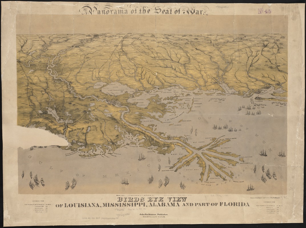
Birds eye view of Louisiana, Mississippi, Alabama and part of Florida
Birds eye view of Louisiana, Mississippi, Alabama and part of Florida
×
Item Information
Title:
Birds eye view of Louisiana, Mississippi, Alabama and part of Florida
Title (alt.):
Panorama of the seat of war, birds eye view of Louisiana, Mississippi, Alabama and part of Florida
Creator:
Bachmann, John, fl. 1849-1885
Name on Item:
drawn from nature and lith. by John Bachmann.
Date:
1861
Format:
Maps/Atlases
Location:
Boston Public Library
Norman B. Leventhal Map Center
Collection (local):
Norman B. Leventhal Map Center Collection
Subjects:
Louisiana--History--Civil War, 1861-1865--Aerial views
Mississippi--Aerial views
Mississippi--History--Civil War, 1861-1865--Aerial views
Alabama--Aerial views
Alabama--History--Civil War, 1861-1865--Aerial views
Florida--Aerial views
Florida--History--Civil War, 1861-1865--Aerial views
Places:
Alabama
Louisiana
Mississippi
Florida
Extent:
1 view : col. ; 47 x 72 cm.
Permalink:
https://ark.digitalcommonwealth.org/ark:/50959/wd376222g
Terms of Use:
No known copyright restrictions.
No known restrictions on use.
Publisher:
New York : J. Bachmann
Scale:
Not drawn to scale.
Language:
English
Notes:
Includes distance chart.
Identifier:
06_01_003683
Call #:
G4011.A3 1861 .B33
Barcode:
39999059001675
show more...
View MODS XML
More Like This
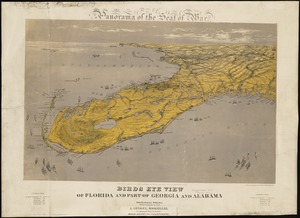
Birds eye view of Florida and part of Georgia and Alabama
The 100th anniversary map of Abraham Lincoln's visit to ...
1630 shoreline
1879. Progress map of the U.S. Geographical Surveys west of the ...
Find More Like This >>
Tools
Share
Facebook
Pinterest
X
Reddit
Tumblr
Email
Copy link
Add to Folder
Questions/Comments
Cite This Item
IIIF Manifest
Downloads
Primary (full resolution, uncompressed)
(TIF, 183 MB)
Large (full resolution)
(JPEG, 15.4 MB)
Medium
(JPEG, 290 KB)