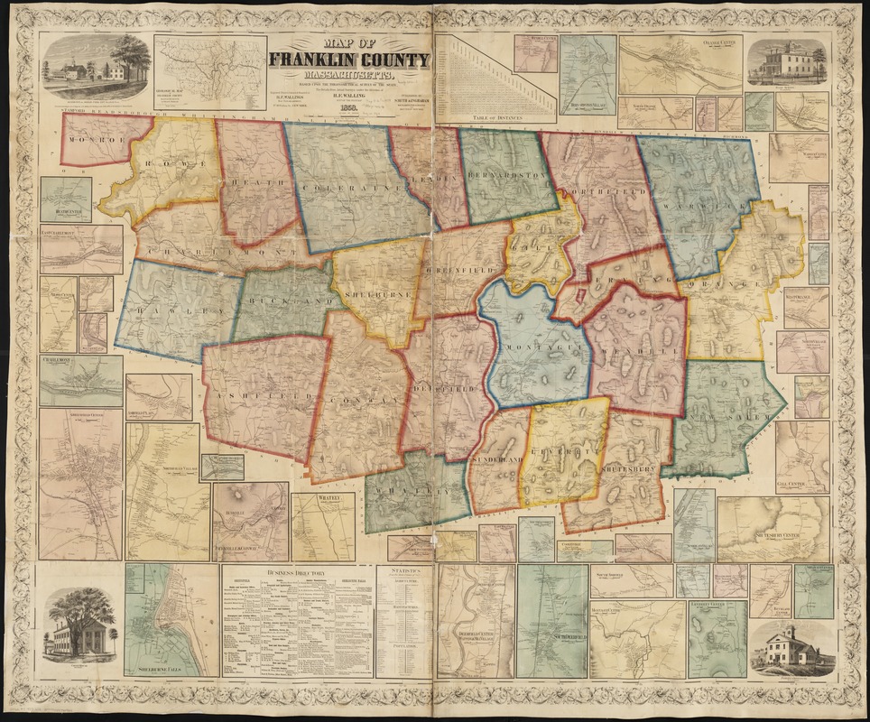
Shows names of streets, boundaries of townships, and surrounding county names, drainage, with names of residence, and other points of interest.
Relief shown by hachures.
Formerly a wall-map.
Includes : Business directory; Statistics of agriculture, manufactures, and population; and Table of distances.
Engravings "photographed by E. C. Ely, Greenfield, Mass." at corners: Residence of Josiah Fogg, Esq., Deerfield, Mass -- Courthouse Greenfield -- High School , Greenfield -- Power Institute, Bernardston.
Insets: Geological map of Franklin County, Massachusetts / by Edward Hitchcock -- Heath Center -- East Charlemont -- Rowe Center -- Mantague Canal -- Charlemont -- Ashfield Plain -- Greenfield Center -- Northfield Village -- Cheapside (Deerfield) -- Burkville & Conway -- Whately -- Shelburne Falls -- Grouts Corner, Montagaue -- West Whately -- East Whately -- Deerfield Center, Wapping [&] Mill Village -- South Leverette -- Cooleyville, New Salem -- North Leverette -- South Ashfield -- Montague Center -- Sunderland Village -- Leydon Center -- Millington, New Salem -- Leverette Center -- Shutesbury Center -- Buckland Center -- Shelburne Center -- Gill Center -- Wendell Depot -- North Village New Salem -- West Orange -- Northfield Farms -- New Salem Center -- Warwick Center -- Eriving Center -- Coleraine Center -- Shattuckville Coleraine -- Griswouldville Coleraine -- North Orange -- Orange Center -- Bernardston Village -- Wendell Center.

![[Map of the towns of Western Massachusetts]](https://bpldcassets.blob.core.windows.net/derivatives/images/commonwealth:6108vv02d/image_thumbnail_300.jpg)
