Skip to search
Skip to main content
Digital Commonwealth
Sign Up / Log In
Search for
Search
Search
Search
Basic
Advanced
Explore
Map
Collections
Institutions
Formats
For Educators
Primary Source Sets
Lesson Plans
Using Primary Sources
Searching Digital Commonwealth
For Institutions
Join Digital Commonwealth
Conferences, Trainings, & Events
How to Contribute Collections
Digitization Services
Board & Committees
Frequently Asked Questions
About
About Digital Commonwealth
News & Announcements
Copyright & Terms of Use
Harmful Content Statement
Partners
API
Contact Us
Boston Public Library
Norman B. Leventhal Map Center Collection
/
Urban Maps (Collection of Distinction)
/
Boston and New England Maps (Collection of Distinction)
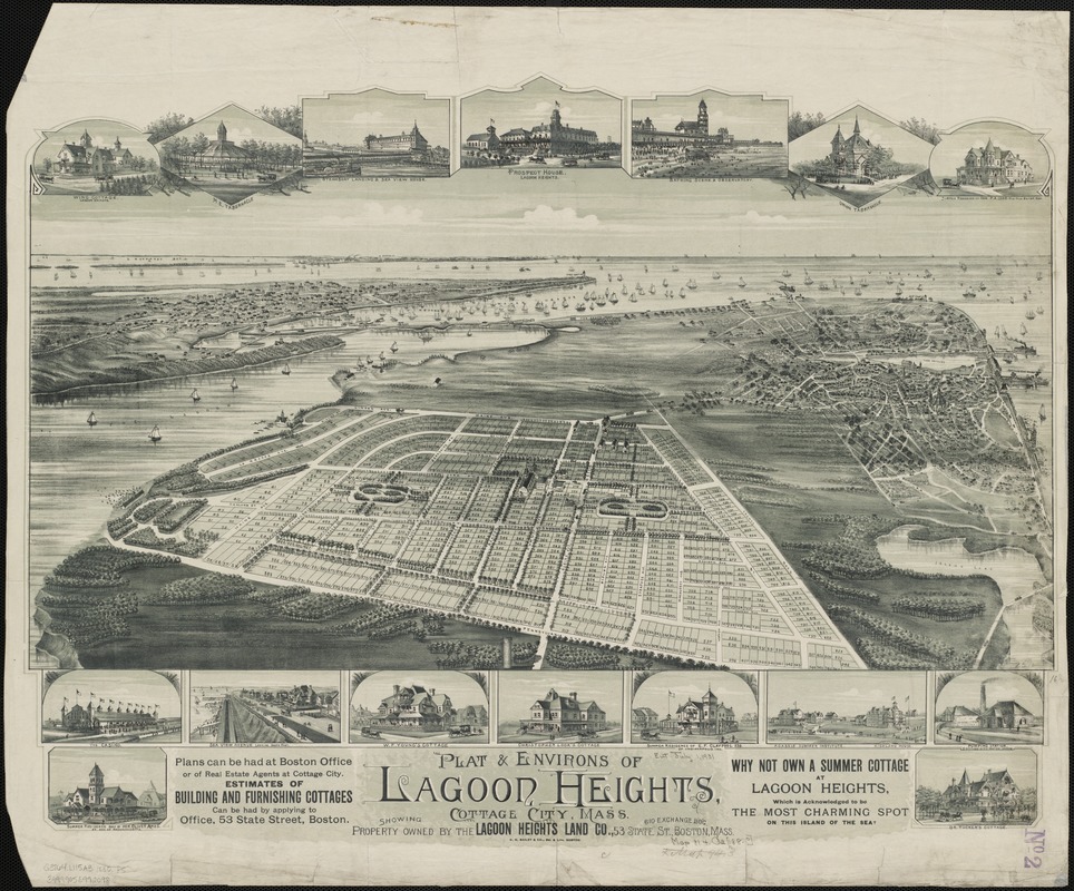
Plat & environs of Lagoon Heights : showing property owned by the Lagoon Heights Land Co
Plat & environs of Lagoon Heights
×
Item Information
Title:
Plat & environs of Lagoon Heights : showing property owned by the Lagoon Heights Land Co
Title (alt.):
Plat and environs of Lagoon Heights : showing property owned by the Lagoon Heights Land Co
Creator:
O.H. Bailey & Co
Name on Item:
O.H. Bailey & Co. del. & lith.
Date:
1880
Format:
Maps/Atlases
Location:
Boston Public Library
Norman B. Leventhal Map Center
Collection (local):
Norman B. Leventhal Map Center Collection
Subjects:
Real estate development--Massachusetts--Lagoon Heights
Lagoon Heights (Mass.)--Aerial views
Oak Bluffs (Mass.)--Aerial views
Places:
Massachusetts
>
Dukes (county)
>
Martha's Vineyard
(island)
>
Oak Bluffs
>
Lagoon Heights
Extent:
1 view : col. ; 50 x 66 cm.
Permalink:
https://ark.digitalcommonwealth.org/ark:/50959/wd375z999
Terms of Use:
No known copyright restrictions.
No known restrictions on use.
Publisher:
Boston : O.H. Bailey & Co.
Scale:
Not drawn to scale.
Language:
English
Notes:
Bird's-eye view.
Includes ill.
Identifier:
06_01_002153
Call #:
G3764.L115A3 1880 .P5
Barcode:
39999058992098
show more...
View MODS XML
More Like This
Cottage City, Martha's Vineyard, Mass
The 100th anniversary map of Abraham Lincoln's visit to ...
1630 shoreline
1879. Progress map of the U.S. Geographical Surveys west of the ...
Find More Like This >>
Tools
Share
Facebook
Pinterest
X
Reddit
Tumblr
Email
Copy link
Add to Folder
Questions/Comments
Cite This Item
IIIF Manifest
Downloads
Primary (full resolution, uncompressed)
(TIF, 179 MB)
Large (full resolution)
(JPEG, 15 MB)
Medium
(JPEG, 323 KB)