Skip to search
Skip to main content
Digital Commonwealth
Sign Up / Log In
Search for
Search
Search
Search
Basic
Advanced
Explore
Map
Collections
Institutions
Formats
For Educators
Primary Source Sets
Lesson Plans
Using Primary Sources
Searching Digital Commonwealth
For Institutions
Join Digital Commonwealth
Conferences, Trainings, & Events
How to Contribute Collections
Digitization Services
Board & Committees
Frequently Asked Questions
About
About Digital Commonwealth
News & Announcements
Copyright & Terms of Use
Harmful Content Statement
Partners
API
Contact Us
Boston Public Library
Norman B. Leventhal Map Center Collection
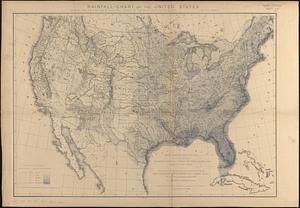
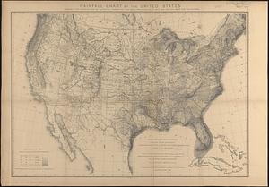
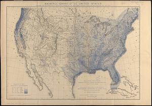
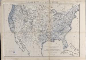
Rainfall-chart of the United States : showing the distribution by isohyetal curves of the mean precipitation in rain ...
Viewing image 1 of 5
Next >
Rainfall-chart of the United States
×
Next
Item Information
Title:
Rainfall-chart of the United States : showing the distribution by isohyetal curves of the mean precipitation in rain ...
Cartographer:
Schott, Charles A. (Charles Anthony), 1826-1901
Name on Item:
constructed by Charles A. Schott
Date:
1880
Format:
Maps/Atlases
Location:
Boston Public Library
Norman B. Leventhal Map Center
Collection (local):
Norman B. Leventhal Map Center Collection
Subjects:
United States--Maps
Rain and rainfall--United States--Maps
Places:
Extent:
5 maps : mounted on linen ; 49 x 71 cm
Permalink:
https://ark.digitalcommonwealth.org/ark:/50959/st74g797p
Terms of Use:
No known copyright restrictions.
No known restrictions on use.
Place of origin:
Washington, D.C.
Edition:
2nd ed. including records to 1877
Scale:
Scale not given
Language:
English
Table of Contents:
1. Mean spring precipitation
2. Mean summer precipitation
3. Mean autumn precipitation
4. Mean winter precipitation
5. Mean annual precipitation
Notes:
Relief shown by hachures.
"From material collected and observations made for the Smithsonian Institute."
Identifier:
06_01_016977A
06_01_016977B
06_01_016977C
06_01_016977D
06_01_016977E
Call #:
G3701.C883 1880 .S36
Barcode:
39999085943726
show more...
View MODS XML
More Like This
19th annual convention of the National Association of Real Estate ...
2005 significant U.S. hurricane strikes
38,000,000 escaped -- 10,000,000 died
Aboriginal map of North America, denoting the boundaries and the ...
Find More Like This >>
Tools
Share
Facebook
Pinterest
X
Reddit
Tumblr
Email
Copy link
Add to Folder
Questions/Comments
Cite This Item
IIIF Manifest
Downloads
Primary (full resolution, uncompressed)
(TIF, multi-file ZIP, 468 MB)
Large (full resolution)
(JPEG, multi-file ZIP, 4.14 MB)
Medium
(JPEG, multi-file ZIP, 470 KB)