Skip to search
Skip to main content
Digital Commonwealth
Sign Up / Log In
Search for
Search
Search
Search
Basic
Advanced
Explore
Map
Collections
Institutions
Formats
For Educators
Primary Source Sets
Lesson Plans
Using Primary Sources
Searching Digital Commonwealth
For Institutions
Join Digital Commonwealth
Conferences, Trainings, & Events
How to Contribute Collections
Digitization Services
Board & Committees
Frequently Asked Questions
About
About Digital Commonwealth
News & Announcements
Copyright & Terms of Use
Harmful Content Statement
Partners
API
Contact Us
Boston Public Library
Norman B. Leventhal Map Center Collection
/
Boston and New England Maps (Collection of Distinction)
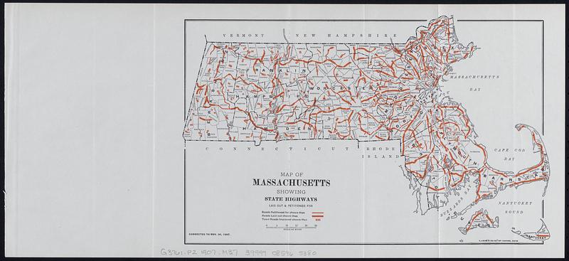
Map of Massachusetts showing state highways laid out & petitioned for
Map of Massachusetts showing state highways laid out & petitioned for
×
Item Information
Title:
Map of Massachusetts showing state highways laid out & petitioned for
Cartographer:
Massachusetts. Highway Commission
Printer:
Wright & Potter
Printer:
C.J. Peters & Son
Date:
[1908]
Format:
Maps/Atlases
Location:
Boston Public Library
Norman B. Leventhal Map Center
Collection (local):
Norman B. Leventhal Map Center Collection
Subjects:
Massachusetts--Maps
Roads--Massachusetts--Maps
Places:
Massachusetts
Extent:
1 map : color ; 19 x 30 cm on sheet 21 x 45 cm
Permalink:
https://ark.digitalcommonwealth.org/ark:/50959/rr174k27z
Terms of Use:
No known copyright restrictions.
No known restrictions on use.
Publisher:
[Boston] : [Wright & Potter Printing Co.]
Scale:
Scale 1:1,025,000
Language:
English
Notes:
Corrected to Nov. 30, 1907.
C.J. Peters & Son, map engravers, Boston.
Detached from Fifteenth annual report of the Massachusetts Highway Commission, for the fiscal year ending November 30, 1907 (Boston : Wright & Potter Printing Co., 1908).
Notes (date):
This date is inferred.
Identifier:
06_01_018336
Call #:
G3761.P2 1907 .M37
Barcode:
39999085965380
show more...
View MODS XML
More Like This
Automobile map of Massachusetts : central section
Boston and its suburban drives
Boston and vicinity
Cyclists' road map of Massachusetts
Find More Like This >>
Tools
Share
Facebook
Pinterest
X
Reddit
Tumblr
Email
Copy link
Add to Folder
Questions/Comments
Cite This Item
IIIF Manifest
Downloads
Primary (full resolution, uncompressed)
(TIF, 37.7 MB)
Large (full resolution)
(JPEG, 3.16 MB)
Medium
(JPEG, 65.1 KB)