Skip to search
Skip to main content
Digital Commonwealth
Sign Up / Log In
Search for
Search
Search
Search
Basic
Advanced
Explore
Map
Collections
Institutions
Formats
For Educators
Primary Source Sets
Lesson Plans
Using Primary Sources
Searching Digital Commonwealth
For Institutions
Join Digital Commonwealth
Conferences, Trainings, & Events
How to Contribute Collections
Digitization Services
Board & Committees
Frequently Asked Questions
About
About Digital Commonwealth
News & Announcements
Copyright & Terms of Use
Harmful Content Statement
Partners
API
Contact Us
Boston Public Library
Norman B. Leventhal Map Center Collection
/
Boston Redevelopment Authority Collection
/
Urban Maps (Collection of Distinction)
/
Boston and New England Maps (Collection of Distinction)
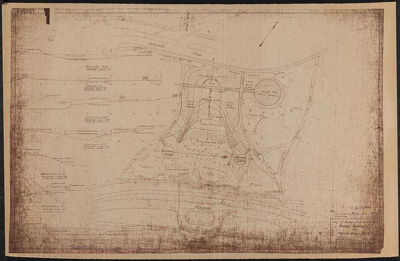
Rose garden in Fens-Back Bay
Rose garden in Fens-Back Bay
×
Item Information
Title:
Rose garden in Fens-Back Bay
Cartographer:
Boston (Mass.). Department of Parks
Name on Item:
City of Boston, Park Department
Date:
1930
Format:
Maps/Atlases
Location:
Boston Public Library
Norman B. Leventhal Map Center
Collection (local):
Norman B. Leventhal Map Center Collection
Series:
Boston Redevelopment Authority Maps & Manuscript Plans Collection
Subjects:
Parks--Massachusetts--Boston--Maps
City planning--Massachusetts--Boston--Maps
Fenway (Boston, Mass.)--Maps
Places:
Suffolk (county)
>
Boston
>
Fens
Extent:
1 map ; 65 x 100 cm
Permalink:
https://ark.digitalcommonwealth.org/ark:/50959/rr174d553
Terms of Use:
No known copyright restrictions.
No known restrictions on use.
Publisher:
[Boston] : City of Boston, Park Department
Scale:
Scale 1:480. 1" = 40'
Language:
English
Notes:
Shows existing and planned paths, shorelines and landscaping.
Relief shown by contours. Depths shown by soundings.
Oriented with north to the upper right.
Includes 7 vertical profiles.
Identifier:
06_01_017854
Call #:
BRA MAP FOLDER 32 no.1
Barcode:
30000007747800
show more...
View MODS XML
More Like This
Back Bay Fens master plan
Back Bay park
The Riverway master plan
Sears Park conceptual site plan with historic waterway
Find More Like This >>
Tools
Share
Facebook
Pinterest
X
Reddit
Tumblr
Email
Copy link
Add to Folder
Questions/Comments
Cite This Item
IIIF Manifest
Downloads
Primary (full resolution, uncompressed)
(TIF, 193 MB)
Large (full resolution)
(JPEG, 16.2 MB)
Medium
(JPEG, 85.3 KB)