Skip to search
Skip to main content
Digital Commonwealth
Sign Up / Log In
Search for
Search
Search
Search
Basic
Advanced
Explore
Map
Collections
Institutions
Formats
For Educators
Primary Source Sets
Lesson Plans
Using Primary Sources
Searching Digital Commonwealth
For Institutions
Join Digital Commonwealth
Conferences, Trainings, & Events
How to Contribute Collections
Digitization Services
Board & Committees
Frequently Asked Questions
About
About Digital Commonwealth
News & Announcements
Copyright & Terms of Use
Harmful Content Statement
Partners
API
Contact Us
Boston Public Library
Boston Redevelopment Authority Collection
/
Urban Maps (Collection of Distinction)
/
Boston and New England Maps (Collection of Distinction)
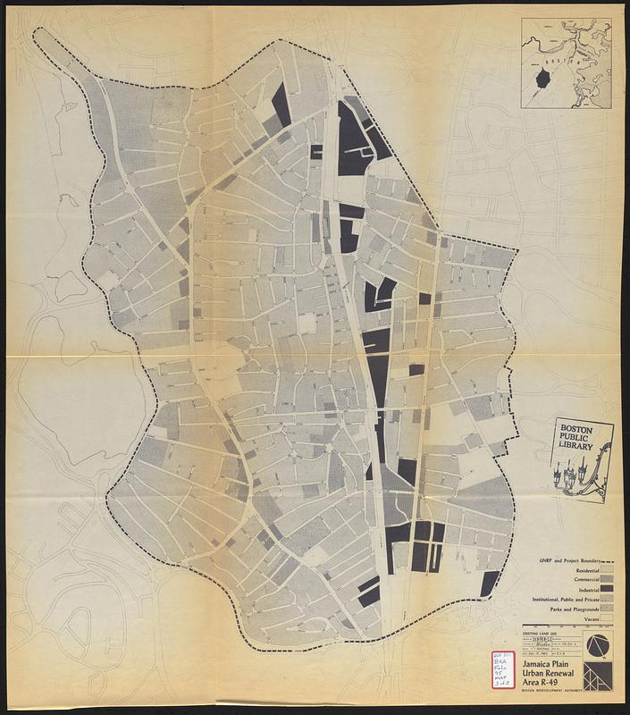
Jamaica Plain urban renewal area r-49 : existing land use
Jamaica Plain urban renewal area r-49
×
Item Information
Title:
Jamaica Plain urban renewal area r-49 : existing land use
Description:
Part of an urban renewal plan for Boston's Jamaica Plain neighborhood.
Publisher:
Boston Redevelopment Authority
Name on Item:
drawn by D.V.H., P.E.N., C.C.
Date:
December 12, 1962
Format:
Maps/Atlases
Location:
Boston Public Library
Central Library in Copley Square
Collection (local):
Boston Public Library Collection
Subjects:
Jamaica Plain (Boston, Mass.)--Maps
City planning--Massachusetts--Boston--Maps
Urban renewal--Massachusetts--Boston--Maps
Land use--Massachusetts--Boston--Maps
Places:
Suffolk (county)
>
Boston
>
Jamaica Plain
Extent:
1 map ; 69 x 61 cm
Permalink:
https://ark.digitalcommonwealth.org/ark:/50959/n8712617t
Terms of Use:
No known copyright restrictions.
No known restrictions on use.
Publisher:
Boston : Boston Redevelopment Authority
Scale:
Scale 1:4,800
Language:
English
Referenced by:
Accompanying text
Notes:
Shows residential; commercial; industrial; institutional, public and private; parks and playground, and vacant.
Inset: [Location map].
Identifier:
06_01_017728
Call #:
BRA/FOLIO/95 map 3
Barcode:
mq6311158
show more...
View MODS XML
More Like This
Jamaica Plain urban renewal area r-49 : proposed land use
1975 general land use plan
Back Bay urban renewal area r-47 : existing land use
Back Bay urban renewal area r-47 : existing land use
Find More Like This >>
Tools
Share
Facebook
Pinterest
X
Reddit
Tumblr
Email
Copy link
Add to Folder
Questions/Comments
Cite This Item
IIIF Manifest
Downloads
Primary (full resolution, uncompressed)
(TIF, 94.9 MB)
Large (full resolution)
(JPEG, 7.97 MB)
Medium
(JPEG, 101 KB)