Wayland Town ClerkWayland Massachusetts Historical Town Records (AKA Sudbury, Massachusetts (1638-1780), East Sudbury, Massachusetts (1780-1835), & Cochituate Massachusetts (1848 to date))
Wayland road book
Item Information
- Title:
- Wayland road book
- Description:
-
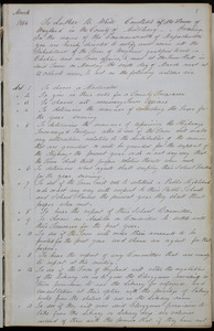
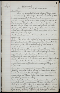
Extracts from the Wayland MA town records concerning county roads, proprietors’ roads, and town roads that cover the time period 1683 to 1909 has been gathered in one volume. Notes such as the "Masters Brook was the original name brook of the now called Stoneybrook between Waltham and Weston." Genealogical locations can be determined by using the entries. of who lives along the road.
- Date:
-
1683–1909
- Format:
-
Books
- Location:
- Wayland Town Clerk
- Collection (local):
-
Wayland Massachusetts Historical Records
- Subjects:
-
Local geogrphical landmarks
Local landmarks
Roads and byways
Bridges
History
History--Sources
Roads
- Places:
-
Massachusetts > Middlesex (county) > Cochituate
Massachusetts > Middlesex (county) > Wayland
Massachusetts > Middlesex (county) > Framingham
Massachusetts > Middlesex (county) > Natick
Massachusetts > Middlesex (county) > Sudbury
Massachusetts > Middlesex (county) > Weston
Pod Meadow
Sherman Bridge
Sudbury Plantation (Mass.)--Moore saw mill
Sudbury Plantation (Mass.)--Ashen Swamp
Sudbury Plantation (Mass.)--Costte Hill Bridge
Sudbury Plantation (Mass.)--Cow Common
Sudbury Plantation (Mass.)--Gravel pit
Sudbury Plantation (Mass.)--Great Meadow
Sudbury Plantation (Mass.)--Hog House Hill
Sudbury Plantation (Mass.)--Ledge Meadow
Sudbury Plantation (Mass.)--Loker Hill
Sudbury Plantation (Mass.)--Loker's Bottom
Sudbury Plantation (Mass.)--Long Hill
Sudbury Plantation (Mass.)--Point Hill
Sudbury Plantation (Mass.)--River Meadow
Sudbury Plantation (Mass.)--Spruce Swamp
Sudbury Plantation (Mass.)--Stone's Bridge
Sudbury Plantation (Mass.)--Training Field
Sudbury Plantation (Mass.)--Whales Bridge
Wayland (Mass.)--Sand Hill
- Extent:
- 1 item (174 pages)
- Permalink:
- https://ark.digitalcommonwealth.org/ark:/50959/mp48wd04k
- Terms of Use:
-
No known copyright restrictions.
No known restrictions on use.
- Language:
-
English
- Notes:
-
Title supplied by cataloger.
Extracts from the Wayland MA town records concerning county roads, proprietors’ roads, town roads that cover the time period 1798 to 1908 has been gathered in one volume. Genealogical locations can be determined.
Additional included locations: Cow Common, Moore saw mill, Ashen Swamp, Hog House Hill, Ledge Meadow, Long hill, Training Field, Loker Hill, Spruce Swamp, Whales Bridge, Costte Hill Bridge, River Meadow, Great Meadow, Gravel pit, Point Hill, Loker's Bottom, Stone's Bridge, and Sand Hill.
Additional name: Parris, Samuel.
- Notes (date):
-
Date from item or accompanying material.
- Identifier:
-
10-14
09.292
Downloads
- Primary (full resolution, uncompressed)(TIF, multi-file ZIP, 14.6 GB)
- Large (full resolution)(JPEG, multi-file ZIP, 65.9 MB)
- Medium(JPEG, multi-file ZIP, 25.1 MB)