Skip to search
Skip to main content
Digital Commonwealth
Sign Up / Log In
Search for
Search
Search
Search
Basic
Advanced
Explore
Map
Collections
Institutions
Formats
For Educators
Primary Source Sets
Lesson Plans
Using Primary Sources
Searching Digital Commonwealth
For Institutions
Join Digital Commonwealth
Conferences, Trainings, & Events
How to Contribute Collections
Digitization Services
Board & Committees
Frequently Asked Questions
About
About Digital Commonwealth
News & Announcements
Copyright & Terms of Use
Harmful Content Statement
Partners
API
Contact Us
Boston Public Library
Norman B. Leventhal Map Center Collection
/
Urban Maps (Collection of Distinction)
/
Boston and New England Maps (Collection of Distinction)
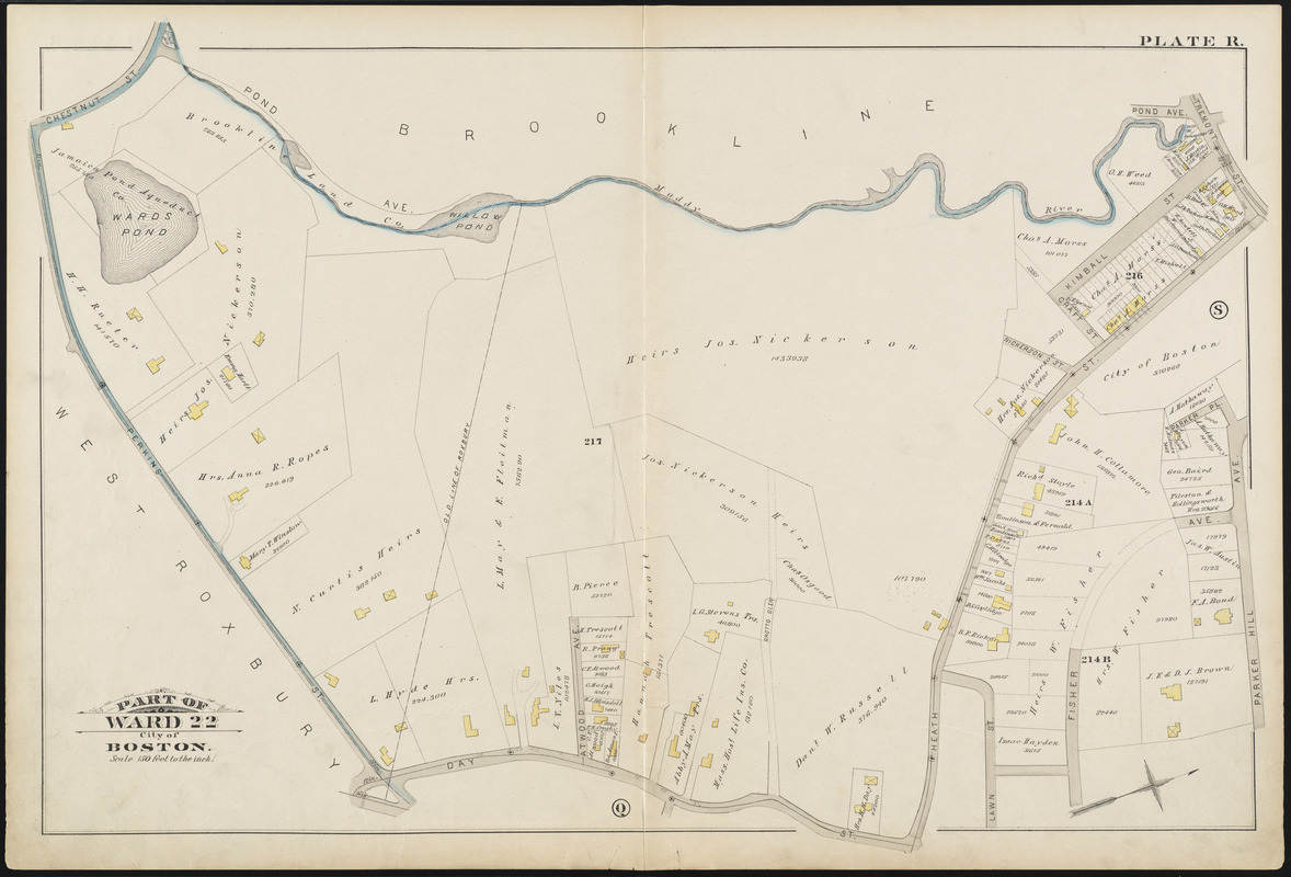
Atlas of the city of Boston : Roxbury : plate R
Atlas of the city of Boston : Roxbury
×
Item Information
Title:
Atlas of the city of Boston : Roxbury : plate R
Creator:
G.W. Bromley & Co.
Date:
1884
Format:
Maps/Atlases
Location:
Boston Public Library
Norman B. Leventhal Map Center
Collection (local):
Norman B. Leventhal Map Center Collection
Subjects:
Boston (Mass.)--Maps
Real property--Massachusetts--Boston--Maps
Landowners--Massachusetts--Boston--Maps
Jamaica Plain (Boston, Mass.)--Maps
Places:
Massachusetts
>
Suffolk (county)
>
Boston
>
Roxbury
Massachusetts
>
Suffolk (county)
>
Boston
>
Jamaica Plain
Extent:
1 map : color ; 51 x 77 cm
Permalink:
https://ark.digitalcommonwealth.org/ark:/50959/m900r565w
Terms of Use:
No known copyright restrictions.
No known restrictions on use.
Publisher:
Philadelphia : G.W. Bromley & Co.
Scale:
Scale 1:1,800
Language:
English
Identifier:
06_01_012744
Call #:
G1234.B6 B7 1883 v.2
Barcode:
39999059010916
show more...
View MODS XML
More Like This
Atlas of the city of Boston : Roxbury : from actual surveys and ...
Atlas of the city of Boston, Roxbury : plate 20
Atlas of the city of Boston, Roxbury : plate 22
Atlas of the city of Boston, Roxbury : plate 20
Find More Like This >>
Tools
Share
Facebook
Pinterest
X
Reddit
Tumblr
Email
Copy link
Add to Folder
Questions/Comments
Cite This Item
Downloads
Primary (full resolution, uncompressed)
(TIF, 110 MB)
Large (full resolution)
(JPEG, 9.25 MB)
Medium
(JPEG, 248 KB)
GeoTIFF (georeferenced)
(TIF, 103 MB)