Skip to search
Skip to main content
Digital Commonwealth
Sign Up / Log In
Search for
Search
Search
Search
Basic
Advanced
Explore
Map
Collections
Institutions
Formats
For Educators
Primary Source Sets
Lesson Plans
Using Primary Sources
Searching Digital Commonwealth
For Institutions
Join Digital Commonwealth
Conferences, Trainings, & Events
How to Contribute Collections
Digitization Services
Board & Committees
Frequently Asked Questions
About
About Digital Commonwealth
News & Announcements
Copyright & Terms of Use
Harmful Content Statement
Partners
API
Contact Us
Boston Public Library
Norman B. Leventhal Map Center Collection
/
Urban Maps (Collection of Distinction)
/
Boston and New England Maps (Collection of Distinction)
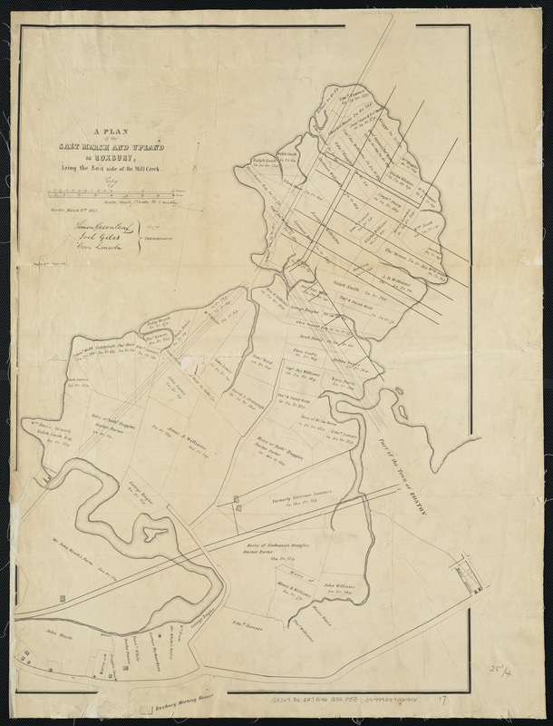
A plan of the salt marsh and upland in Roxbury, lying the east side of the Mill Creek
A plan of the salt marsh and upland in Roxbury, lying the east side of the Mill Creek
×
Item Information
Title:
A plan of the salt marsh and upland in Roxbury, lying the east side of the Mill Creek
Name on Item:
Simon Greenleaf, Joel Giles, Ezra Lincoln, commissioners.
Date:
1852
Format:
Maps/Atlases
Location:
Boston Public Library
Norman B. Leventhal Map Center
Collection (local):
Norman B. Leventhal Map Center Collection
Subjects:
Real property--Massachusetts--Boston--Roxbury--Maps
Land tenure--Massachusetts--Boston--Roxbury--Maps
Roxbury (Boston, Mass.)--Maps
Places:
Suffolk (county)
>
Boston
>
Roxbury
Extent:
1 map ; 66 x 46 cm.
Permalink:
https://ark.digitalcommonwealth.org/ark:/50959/js956j178
Terms of Use:
No known copyright restrictions.
No known restrictions on use.
Publisher:
[Boston, Mass.] : Tappan & Bradford's Lith
Scale:
Scale: 1:3,335.
Language:
English
Notes:
Oriented with north toward the upper right.
Issued with: Massachusetts Senate documents, 1852 (no. 45).
Identifier:
06_01_003895
Call #:
G3764.B6:2R7G46 1852 .P53
Barcode:
39999059002616
show more...
View MODS XML
More Like This
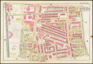
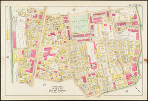
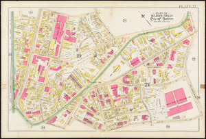
Atlas of the city of Boston : Boston proper and Roxbury : from ...
Atlas of the city of Boston : city proper and Roxbury : plate 23
Atlas of the city of Boston : city proper and Roxbury : plate 24
Atlas of the city of Boston : city proper and Roxbury : plate 25
Find More Like This >>
Tools
Share
Facebook
Pinterest
X
Reddit
Tumblr
Email
Copy link
Add to Folder
Questions/Comments
Cite This Item
IIIF Manifest
Downloads
Primary (full resolution, uncompressed)
(TIF, 47.9 MB)
Large (full resolution)
(JPEG, 4.02 MB)
Medium
(JPEG, 156 KB)