Skip to search
Skip to main content
Digital Commonwealth
Sign Up / Log In
Search for
Search
Search
Search
Basic
Advanced
Explore
Map
Collections
Institutions
Formats
For Educators
Primary Source Sets
Lesson Plans
Using Primary Sources
Searching Digital Commonwealth
For Institutions
Join Digital Commonwealth
Conferences, Trainings, & Events
How to Contribute Collections
Digitization Services
Board & Committees
Frequently Asked Questions
About
About Digital Commonwealth
News & Announcements
Copyright & Terms of Use
Harmful Content Statement
Partners
API
Contact Us
Boston Public Library
Norman B. Leventhal Map Center Collection
/
Urban Maps (Collection of Distinction)
/
Boston and New England Maps (Collection of Distinction)
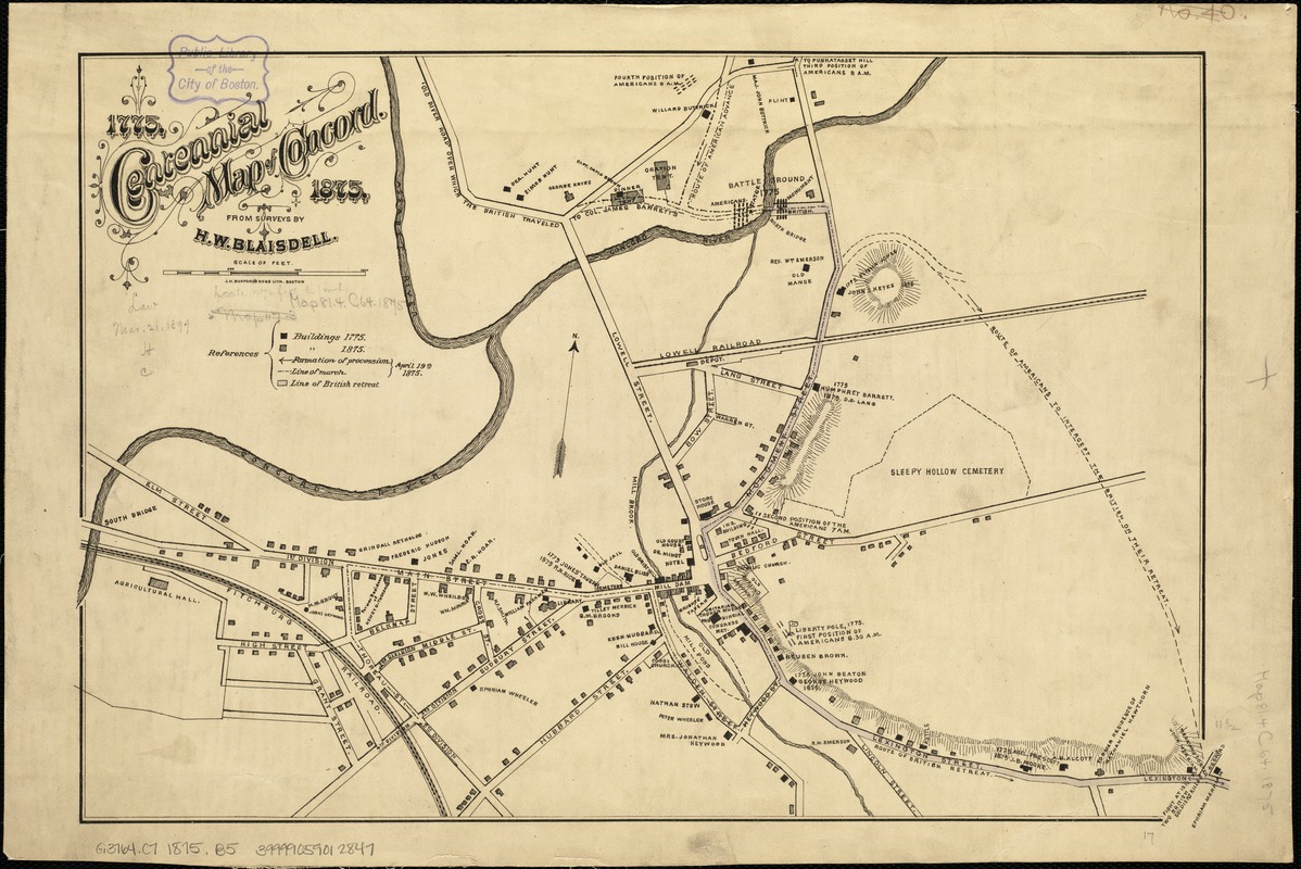
Centennial map of Concord, 1775-1875
Centennial map of Concord, 1775-1875
×
Item Information
Title:
Centennial map of Concord, 1775-1875
Creator:
Blaisdell, H. W.
Name on Item:
from surveys by H.W. Blaisdell.
Date:
[1875]
Format:
Maps/Atlases
Location:
Boston Public Library
Norman B. Leventhal Map Center
Collection (local):
Norman B. Leventhal Map Center Collection
Subjects:
Concord, Battle of, Concord, Mass., 1775--Maps
Landowners--Massachusetts--Concord--Maps
Real property--Massachusetts--Concord--Maps
Concord (Mass.)--Maps
Massachusetts--History--Revolution, 1775-1783--Maps
United States--History--Revolution, 1775-1783--Maps
Places:
Middlesex (county)
>
Concord
Extent:
1 map : hand col. ; 30 X 44 cm.
Permalink:
https://ark.digitalcommonwealth.org/ark:/50959/js956j09k
Terms of Use:
No known copyright restrictions.
No known restrictions on use.
Publisher:
Boston : J.H. Bufford's Sons Lith.
Scale:
Scale [ca. 1:6,000].
Language:
English
Notes:
Oriented with north to the upper right.
Relief shown by hachures.
Shows locations of structures in 1775 and 1875 and gives names of landowners.
Notes (date):
This date is inferred.
Identifier:
06_01_005312
Call #:
G3764.C7 1875 .B5
Barcode:
39999059012847
show more...
View MODS XML
More Like This
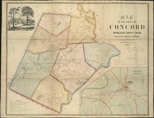
Map of the town of Concord : Middlesex County Mass., surveyed by ...
A plan of the town and harbour of Boston. : And the country ...
A map of Concord, the old Musketaquid Plantation
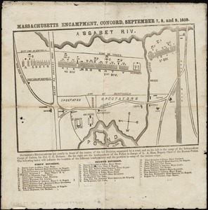
Massachusetts Encampment, Concord, September 7, 8, and 9, 1859
Find More Like This >>
Tools
Share
Facebook
Pinterest
X
Reddit
Tumblr
Email
Copy link
Add to Folder
Questions/Comments
Cite This Item
IIIF Manifest
Downloads
Primary (full resolution, uncompressed)
(TIF, 44.1 MB)
Large (full resolution)
(JPEG, 3.7 MB)
Medium
(JPEG, 326 KB)