Skip to search
Skip to main content
Digital Commonwealth
Sign Up / Log In
Search for
Search
Search
Search
Basic
Advanced
Explore
Map
Collections
Institutions
Formats
For Educators
Primary Source Sets
Lesson Plans
Using Primary Sources
Searching Digital Commonwealth
For Institutions
Join Digital Commonwealth
Conferences, Trainings, & Events
How to Contribute Collections
Digitization Services
Board & Committees
Frequently Asked Questions
About
About Digital Commonwealth
News & Announcements
Copyright & Terms of Use
Harmful Content Statement
Partners
API
Contact Us
Boston Public Library
Norman B. Leventhal Map Center Collection
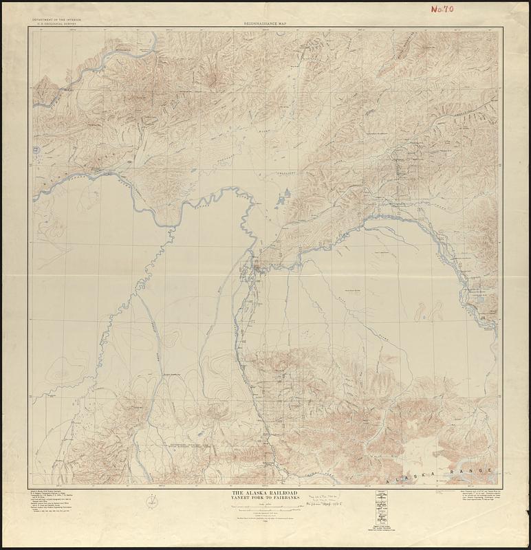
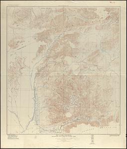
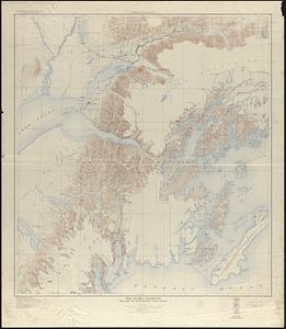
The Alaska Railroad
Viewing image 1 of 3
Next >
The Alaska Railroad
×
Next
Item Information
Title:
The Alaska Railroad
Title (alt.):
Reconnaissance map
Cartographer:
Geological Survey (U.S.)
Cartographer:
Bagley, James Warren, 1881-1947
Name on Item:
Department of the Interior, U.S. Geological Survey ; topography by J.W. Bagley ... [et al.]
Date:
1924
Format:
Maps/Atlases
Genre:
Topographic maps
Location:
Boston Public Library
Norman B. Leventhal Map Center
Collection (local):
Norman B. Leventhal Map Center Collection
Subjects:
Alaska--Maps
Denali National Park and Preserve (Alaska)--Maps
Railroads--Alaska--Maps
Alaska Railroad
Places:
Alaska
Alaska
>
Denali
(area)
>
Denali National Park
Extent:
1 map on 3 sheets : color ; 104 x 92 cm or smaller
Permalink:
https://ark.digitalcommonwealth.org/ark:/50959/j9604j37f
Terms of Use:
No known copyright restrictions.
No known restrictions on use.
Publisher:
[Washington, D.C.] : The Survey
Scale:
Scale 1:250,000
Language:
English
Table of Contents:
Yanert Fork to Fairbanks
Matanuska coal field to Yanert Fork
Seward to Matanuska coal field
Notes:
Relief shown by contours and spot heights.
Extends from Seward to Fairbanks and includes most of Mount McKinley National Park.
Identifier:
06_01_017008B
06_01_017008A
06_01_017008C
Call #:
G4371.P3 1924 .G46
Barcode:
39999065684092
show more...
View MODS XML
More Like This
Bacon's new large-print map of Alaska & the Klondike : compiled ...
Map of Alaska : showing latest explorations by U.S. Geological ...
Map of White Pass & Yukon Route and connections
Map railway route, Seward to Fairbanks : (including Matanuska - ...
Find More Like This >>
Tools
Share
Facebook
Pinterest
X
Reddit
Tumblr
Email
Copy link
Add to Folder
Questions/Comments
Cite This Item
IIIF Manifest
Downloads
Primary (full resolution, uncompressed)
(TIF, multi-file ZIP, 567 MB)
Large (full resolution)
(JPEG, multi-file ZIP, 5.01 MB)
Medium
(JPEG, multi-file ZIP, 296 KB)