Skip to search
Skip to main content
Digital Commonwealth
Sign Up / Log In
Search for
Search
Search
Search
Basic
Advanced
Explore
Map
Collections
Institutions
Formats
For Educators
Primary Source Sets
Lesson Plans
Using Primary Sources
Searching Digital Commonwealth
For Institutions
Join Digital Commonwealth
Conferences, Trainings, & Events
How to Contribute Collections
Digitization Services
Board & Committees
Frequently Asked Questions
About
About Digital Commonwealth
News & Announcements
Copyright & Terms of Use
Harmful Content Statement
Partners
API
Contact Us
Phillips Academy
Sidney R. Knafel Map Collection at Phillips Academy
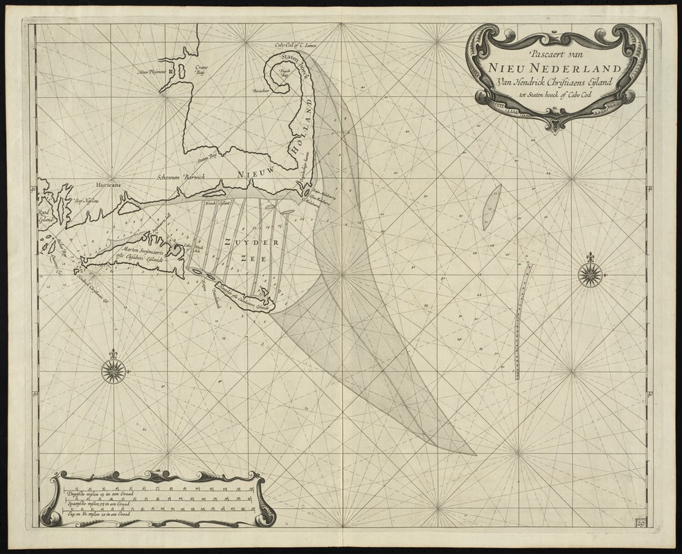
Pascaert van Nieu Nederland van Hendrick Christiaens Eijland tot staten hoeck of Cabo Cod
Pascaert van Nieu Nederland van Hendrick Christiaens Eijland tot staten hoeck of Cabo Cod
×
Item Information
Title:
Pascaert van Nieu Nederland van Hendrick Christiaens Eijland tot staten hoeck of Cabo Cod
Title (alt.):
Pascaert van Nieu Nederland van Hendrick Christiaens Eyland tot staten hoeck of Cabo Cod
Creator:
Roggeveen, Arent, -1679
Contributor:
Goos, Pieter, approximately 1616-1675
Date:
[1675]
Format:
Maps/Atlases
Location:
Phillips Academy
Collection (local):
Sidney R. Knafel Map Collection at Phillips Academy, Andover MA
Subjects:
Cape Cod (Mass)--Maps--Early works to 1800
Nautical charts--North Atlantic Ocean--Early works to 1800
Places:
Barnstable (county)
>
Cape Cod
(area)
Extent:
1 map ; 41 x 50 cm.
Permalink:
https://ark.digitalcommonwealth.org/ark:/50959/hq37vv869
Terms of Use:
Rights status not evaluated.
Contact host institution for more information.
Publisher:
[Amsterdam] : [Pieter Goos]
Scale:
Scale [ca. 1:670,000]
Language:
Dutch
Notes:
Depth shown by soundings.
In lower right: 29.
From Roggeveen's Brandende veen.
Notes (date):
This date is inferred.
Notes (citation):
Sabin, J. Dictionary of books relating to America, 72762
Phillips, P. List of geographical atlases, 2694
Identifier:
1332
show more...
View MODS XML
More Like This
A chart of the Atlantic Ocean : its islands and the adjacent ...
A new chart of the Atlantic or Western Ocean
A new chart of the vast Atlantic Ocean
Pascaerte vande Vlaemsche, Soute, en Caribesche Eylanden, als mede ...
Find More Like This >>
Tools
Share
Facebook
Pinterest
X
Reddit
Tumblr
Email
Copy link
Add to Folder
Questions/Comments
Cite This Item
IIIF Manifest