Skip to search
Skip to main content
Digital Commonwealth
Sign Up / Log In
Search for
Search
Search
Search
Basic
Advanced
Explore
Map
Collections
Institutions
Formats
For Educators
Primary Source Sets
Lesson Plans
Using Primary Sources
Searching Digital Commonwealth
For Institutions
Join Digital Commonwealth
Conferences, Trainings, & Events
How to Contribute Collections
Digitization Services
Board & Committees
Frequently Asked Questions
About
About Digital Commonwealth
News & Announcements
Copyright & Terms of Use
Harmful Content Statement
Partners
API
Contact Us
Boston Public Library
Norman B. Leventhal Map Center Collection
/
Urban Maps (Collection of Distinction)
/
Boston and New England Maps (Collection of Distinction)
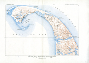
Atlas of Barnstable County, Massachusetts : towns of Bourne, Mashpee, Falmouth, Sandwich, Barnstable, Yarmouth, Dennis, Harwich, Brewster, Chatham, Orleans, Eastham, Wellfleet, Truro & Provincetown
Read online
Item Information
Title:
Atlas of Barnstable County, Massachusetts : towns of Bourne, Mashpee, Falmouth, Sandwich, Barnstable, Yarmouth, Dennis, Harwich, Brewster, Chatham, Orleans, Eastham, Wellfleet, Truro & Provincetown
Publisher:
Walker Lith. & Pub. Co.
Name on Item:
from official plans and actual surveys
Date:
[1910]
Format:
Maps/Atlases
Books
Location:
Boston Public Library
Norman B. Leventhal Map Center
Collection (local):
Norman B. Leventhal Map Center Collection
Subjects:
Barnstable County (Mass.)--Maps
Bourne (Mass.)--Maps
Sandwich (Mass.)--Maps
Barnstable (Mass.)--Maps
Wellfleet (Mass.)--Maps
Truro (Mass. : Town)--Maps
Yarmouth (Mass.)--Maps
Brewster (Mass.)--Maps
Chatham (Mass.)--Maps
Dennis (Mass. : Town)--Maps
Eastham (Mass. : Town)--Maps
Falmouth (Mass. : Town)--Maps
Harwich (Mass.)--Maps
Mashpee (Mass. : Town)--Maps
Orleans (Mass.)--Maps
Provincetown (Mass.)--Maps
Landowners--Massachusetts--Barnstable County--Maps
Real property--Massachusetts--Barnstable County--Maps
Places:
Barnstable (county)
Extent:
1 atlas (3 unnumbered leaves (1 folded), 49 folded leaves of plates) : color maps ; 58 cm
Permalink:
https://ark.digitalcommonwealth.org/ark:/50959/fn109m36h
Terms of Use:
No known copyright restrictions.
No known restrictions on use.
Publisher:
Boston : Walker Lithograph & Pub. Co.
Language:
English
Notes (date):
This date is inferred.
Identifier:
06_01_018466
Call #:
G1233.B3 W3 1910
Barcode:
39999059010205
show more...
View MODS XML
More Like This
Atlas of Barnstable County, Massachusetts : towns of Bourne, ...
Atlas of the boundaries of the towns of Barnstable, Brewster, ...
A map of the extremity of Cape Cod : including the townships of ...
Coast Lines: Part of Provincetown and Wellfleet (Mass.) Sheets
Find More Like This >>
Tools
Share
Facebook
Pinterest
X
Reddit
Tumblr
Email
Copy link
Add to Folder
Questions/Comments
Cite This Item
IIIF Manifest
Downloads
Primary (full resolution, uncompressed)
(TIF, multi-file ZIP, 9.37 GB)
Large (full resolution)
(JPEG, multi-file ZIP, 84.7 MB)
Medium
(JPEG, multi-file ZIP, 4.22 MB)