Skip to search
Skip to main content
Digital Commonwealth
Sign Up / Log In
Search for
Search
Search
Search
Basic
Advanced
Explore
Map
Collections
Institutions
Formats
For Educators
Primary Source Sets
Lesson Plans
Using Primary Sources
Searching Digital Commonwealth
For Institutions
Join Digital Commonwealth
Conferences, Trainings, & Events
How to Contribute Collections
Digitization Services
Board & Committees
Frequently Asked Questions
About
About Digital Commonwealth
News & Announcements
Copyright & Terms of Use
Harmful Content Statement
Partners
API
Contact Us
Boston Public Library
Norman B. Leventhal Map Center Collection
/
Boston and New England Maps (Collection of Distinction)
/
Maritime Charts and Atlases (Collection of Distinction)
Block Island, Rhode Island
Block Island, Rhode Island
×
Item Information
Title:
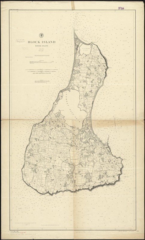
Block Island, Rhode Island
Title in lower right margin :
Block Island
Creator:
U.S. Coast and Geodetic Survey
Name on Item:
issued September 1887, F.M. Thorn, superintendent ; verified, B.A. Colonna ; topography inked by W.H. Dennis ; authorities: topography by W.H. Dennis in 1886 ; hydrography by C.M. Chester in 1878 ; verification of hydrography by W.H. Brownson.
Date:
1888
Format:
Maps/Atlases
Location:
Boston Public Library
Norman B. Leventhal Map Center
Collection (local):
Norman B. Leventhal Map Center Collection
Subjects:
Nautical charts--Rhode Island--Block Island (Island)
Block Island (R.I. : Island)--Maps
Places:
Washington (county)
>
Block Island
(island)
Extent:
1 map ; 125 x 71 cm.
Permalink:
https://ark.digitalcommonwealth.org/ark:/50959/cj82m789j
Terms of Use:
No known copyright restrictions.
No known restrictions on use.
Publisher:
[Washington, D.C.] : United States Coast and Geodetic Survey
Edition:
Aids to navigation corr. to 1888.
Scale:
Scale 1:10,000
Language:
English
Notes:
Relief shown by contours, spot heights, and landform drawings. Depths shown by soundings and isolines.
"No. 356"--Upper left margin.
Identifier:
06_01_010559
Call #:
G3772.B5 1888 .U55
Barcode:
39999065674044
show more...
View MODS XML
More Like This
The Newport yacht race : an exciting game
The 100th anniversary map of Abraham Lincoln's visit to ...
1630 shoreline
1879. Progress map of the U.S. Geographical Surveys west of the ...
Find More Like This >>
Tools
Share
Facebook
Pinterest
X
Reddit
Tumblr
Email
Copy link
Add to Folder
Questions/Comments
Cite This Item
IIIF Manifest
Downloads
Primary (full resolution, uncompressed)
(TIF, 281 MB)
Large (full resolution)
(JPEG, 23.6 MB)
Medium
(JPEG, 130 KB)