Skip to search
Skip to main content
Digital Commonwealth
Sign Up / Log In
Search for
Search
Search
Search
Basic
Advanced
Explore
Map
Collections
Institutions
Formats
For Educators
Primary Source Sets
Lesson Plans
Using Primary Sources
Searching Digital Commonwealth
For Institutions
Join Digital Commonwealth
Conferences, Trainings, & Events
How to Contribute Collections
Digitization Services
Board & Committees
Frequently Asked Questions
About
About Digital Commonwealth
News & Announcements
Copyright & Terms of Use
Harmful Content Statement
Partners
API
Contact Us
Boston Public Library
Norman B. Leventhal Map Center Collection
/
Boston and New England Maps (Collection of Distinction)
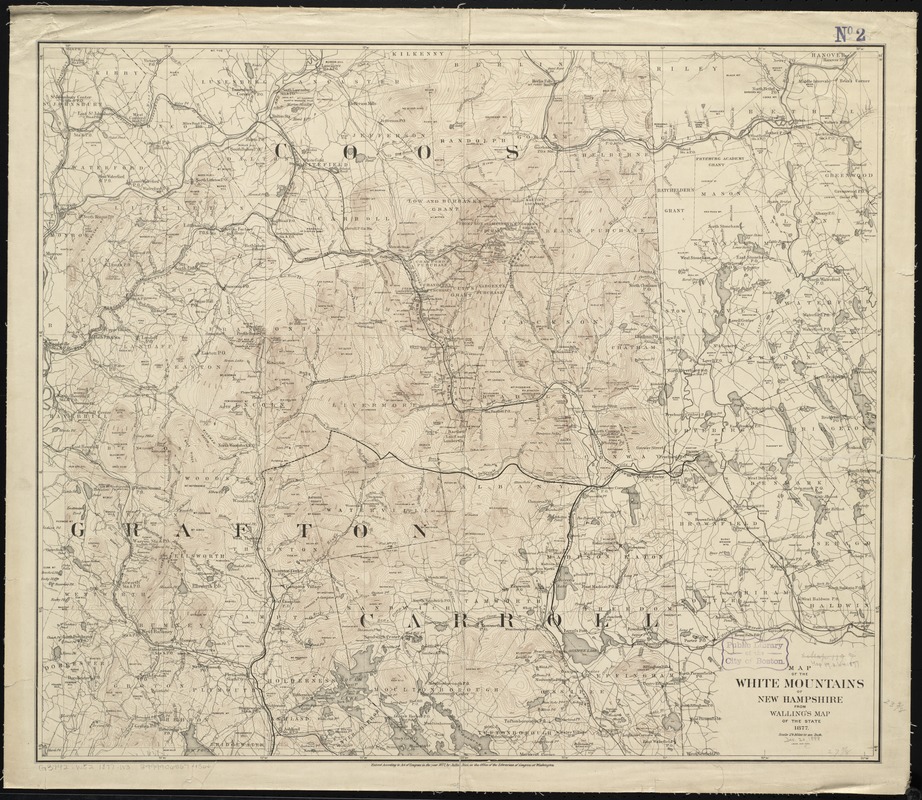
Map of the White Mountains of New Hampshire from Walling's map of the state 1877
Map of the White Mountains of New Hampshire from Wallings map of the state 1877
×
Item Information
Title:
Map of the White Mountains of New Hampshire from Walling's map of the state 1877
Title (alt.):
White Mountains of New Hampshire
Creator:
Walling, Henry Francis, 1825-1888
Date:
1877
Format:
Maps/Atlases
Location:
Boston Public Library
Norman B. Leventhal Map Center
Collection (local):
Norman B. Leventhal Map Center Collection
Subjects:
White Mountains (N.H. and Me.)--Maps
1877
Places:
White Mountains
Extent:
1 map : color, mounted on muslin ; 60 x 71 cm.
Permalink:
https://ark.digitalcommonwealth.org/ark:/50959/cj82m755q
Terms of Use:
No known copyright restrictions.
No known restrictions on use.
Publisher:
New York : J. Bien
Scale:
Scale [1:158,400]. 1 in. to 2 1/2 miles
Language:
English
Notes:
Relief shown by contours.
Identifier:
06_01_010517
Call #:
G3742.W52 1877 .W3
Barcode:
39999065674366
show more...
View MODS XML
More Like This
Karte der White Mountains (Weissen Berge) zur übersicht der ...
Leavitt's map with views of the White Mountains, New Hampshire : 1859
Maine Central Railroad : through the White Mountains
Map of the White Mountains, N.H
Find More Like This >>
Tools
Share
Facebook
Pinterest
X
Reddit
Tumblr
Email
Copy link
Add to Folder
Questions/Comments
Cite This Item
IIIF Manifest
Downloads
Primary (full resolution, uncompressed)
(TIF, 119 MB)
Large (full resolution)
(JPEG, 10 MB)
Medium
(JPEG, 332 KB)
GeoTIFF (georeferenced)
(TIF, 142 MB)