Skip to search
Skip to main content
Digital Commonwealth
Sign Up / Log In
Search for
Search
Search
Search
Basic
Advanced
Explore
Map
Collections
Institutions
Formats
For Educators
Primary Source Sets
Lesson Plans
Using Primary Sources
Searching Digital Commonwealth
For Institutions
Join Digital Commonwealth
Conferences, Trainings, & Events
How to Contribute Collections
Digitization Services
Board & Committees
Frequently Asked Questions
About
About Digital Commonwealth
News & Announcements
Copyright & Terms of Use
Harmful Content Statement
Partners
API
Contact Us
Boston Public Library
Norman B. Leventhal Map Center Collection
/
Maritime Charts and Atlases (Collection of Distinction)
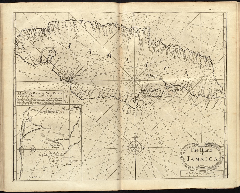
The island of Jamaica
The island of Jamaica
×
Item Information
Title:
The island of Jamaica
Date:
[1737]
Format:
Maps/Atlases
Location:
Boston Public Library
Norman B. Leventhal Map Center
Collection (local):
Norman B. Leventhal Map Center Collection
Subjects:
Nautical charts--Jamaica--Early works to 1800
Nautical charts--Jamaica--Port Royal--Early works to 1800
Jamaica--Maps--Early works to 1800
Places:
Jamaica
Kingston (county)
>
Port Royal
Extent:
1 map ; 41 x 53 cm.
Permalink:
https://ark.digitalcommonwealth.org/ark:/50959/cj82m535t
Terms of Use:
No known copyright restrictions.
No known restrictions on use.
Publisher:
London : Printed & sold by Page and Mount
Scale:
Scale [ca. 1:465,000]
Language:
English
Notes:
Depths shown by soundings.
Inset: A draft of the harbor of Port Royall and of all ye kees: latt: 17d: 50.
In the English pilot, the fourth book. London : Printed for William Mount and Thomas Page, 1737.
Notes (date):
This date is inferred.
Identifier:
06_01_010278
Call #:
G1106.P5 E54 1737
Barcode:
30000003250870
show more...
View MODS XML
More Like This
Carte de l'Isle de la Jamaique
Novissima et accuratissima Insulae Jamaicae
Beschryvinghe der eylanden van Cuba, Hispaniola, Iamaica, S. ...
Carta particolare del'Isola di Cuba è di Iamaica con il capo ...
Find More Like This >>
Tools
Share
Facebook
Pinterest
X
Reddit
Tumblr
Email
Copy link
Add to Folder
Questions/Comments
Cite This Item
IIIF Manifest
Downloads
Primary (full resolution, uncompressed)
(TIF, 104 MB)
Large (full resolution)
(JPEG, 8.75 MB)
Medium
(JPEG, 337 KB)
GeoTIFF (georeferenced)
(TIF, 103 MB)