Skip to search
Skip to main content
Digital Commonwealth
Sign Up / Log In
Search for
Search
Search
Search
Basic
Advanced
Explore
Map
Collections
Institutions
Formats
For Educators
Primary Source Sets
Lesson Plans
Using Primary Sources
Searching Digital Commonwealth
For Institutions
Join Digital Commonwealth
Conferences, Trainings, & Events
How to Contribute Collections
Digitization Services
Board & Committees
Frequently Asked Questions
About
About Digital Commonwealth
News & Announcements
Copyright & Terms of Use
Harmful Content Statement
Partners
API
Contact Us
Boston Public Library
Norman B. Leventhal Map Center Collection
/
Maritime Charts and Atlases (Collection of Distinction)
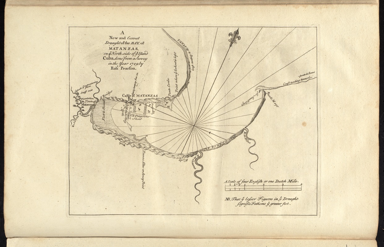
A new and correct draught of the bay of Matanzas : on ye north side of ye island of Cuba ; done from a survey in the year 1729 by Robt. Pearson
A new and correct draught of the bay of Matanzas
×
Item Information
Title:
A new and correct draught of the bay of Matanzas : on ye north side of ye island of Cuba ; done from a survey in the year 1729 by Robt. Pearson
Date:
[1737]
Format:
Maps/Atlases
Location:
Boston Public Library
Norman B. Leventhal Map Center
Collection (local):
Norman B. Leventhal Map Center Collection
Subjects:
Nautical charts--Cuba--Matanzas Bay--Early works to 1800
Matanzas Bay (Cuba)--Maps--Early works to 1800
Places:
Matanzas
(province)
>
Matanzas, Bahía de
(bay)
Extent:
1 map ; 23 x 30 cm.
Permalink:
https://ark.digitalcommonwealth.org/ark:/50959/cj82m531q
Terms of Use:
No known copyright restrictions.
No known restrictions on use.
Publisher:
London : Printed & sold by Page and Mount
Scale:
Scale [ca. 1:69,200]
Language:
English
Notes:
Relief shown pictorially. Depths shown by soundings.
Oriented with north towards the upper right.
In the English pilot, the fourth book. London : Printed for William Mount and Thomas Page, 1737.
Notes (date):
This date is inferred.
Identifier:
06_01_010276
Call #:
G1106.P5 E54 1737
Barcode:
30000003250868
show more...
View MODS XML
More Like This
Plan of the city and harbour of the Havana ; Plan of Bahia de Matanzas
The 100th anniversary map of Abraham Lincoln's visit to ...
1630 shoreline
1879. Progress map of the U.S. Geographical Surveys west of the ...
Find More Like This >>
Tools
Share
Facebook
Pinterest
X
Reddit
Tumblr
Email
Copy link
Add to Folder
Questions/Comments
Cite This Item
IIIF Manifest
Downloads
Primary (full resolution, uncompressed)
(TIF, 54.1 MB)
Large (full resolution)
(JPEG, 4.54 MB)
Medium
(JPEG, 283 KB)