Skip to search
Skip to main content
Digital Commonwealth
Sign Up / Log In
Search for
Search
Search
Search
Basic
Advanced
Explore
Map
Collections
Institutions
Formats
For Educators
Primary Source Sets
Lesson Plans
Using Primary Sources
Searching Digital Commonwealth
For Institutions
Join Digital Commonwealth
Conferences, Trainings, & Events
How to Contribute Collections
Digitization Services
Board & Committees
Frequently Asked Questions
About
About Digital Commonwealth
News & Announcements
Copyright & Terms of Use
Harmful Content Statement
Partners
API
Contact Us
Boston Public Library
Norman B. Leventhal Map Center Collection
/
Maritime Charts and Atlases (Collection of Distinction)
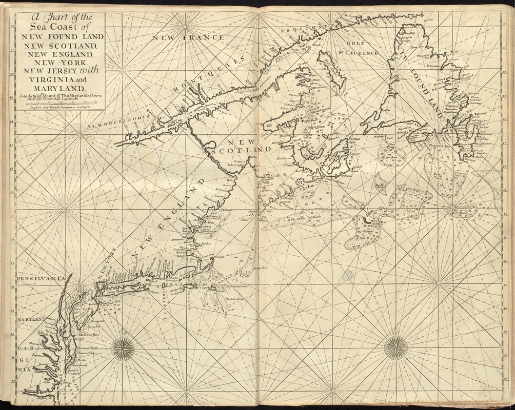
A chart of the sea coast of New Found Land, New Scotland, New England, New York, New Jersey, with Virginia and Maryland
A chart of the sea coast of New Found Land, New Scotland, New England, New York, New Jersey, with Virginia and Maryland
×
Item Information
Title:
A chart of the sea coast of New Found Land, New Scotland, New England, New York, New Jersey, with Virginia and Maryland
Creator:
W. Mount and T. Page
Bookseller:
Page, Thomas, d. 1733
Bookseller:
Mount, William, d. 1769
Date:
[1737]
Format:
Maps/Atlases
Location:
Boston Public Library
Norman B. Leventhal Map Center
Collection (local):
Norman B. Leventhal Map Center Collection
Subjects:
Coasts--Canada, Eastern--Maps--Early works to 1800
Coasts--Middle Atlantic States--Maps--Early works to 1800
Coasts--New England--Maps--Early works to 1800
Nautical charts--Atlantic Coast (North America)--Early works to 1800
Atlantic Coast (North America)--Maps--Early works to 1800
Places:
North America
(area)
New England
(area)
Middle Atlantic
(area)
Canada
Extent:
1 map ; 45 x 56 cm.
Permalink:
https://ark.digitalcommonwealth.org/ark:/50959/cj82m493h
Terms of Use:
No known copyright restrictions.
No known restrictions on use.
Publisher:
London : Sold by Willm. Mount & Tho. Page at the Postern on Great Tower Hill
Scale:
Scale [ca. 1:3,600,000]
Language:
English
Notes:
Depth shown by soundings.
Second state.
In the English pilot, the fourth book. London : Printed for William Mount and Thomas Page, 1737.
Notes (date):
This date is inferred.
Identifier:
06_01_010259
Call #:
G1106.P5 .E54 1737
Barcode:
30000003246685
show more...
View MODS XML
More Like This
An actual survey of the sea coast from New York to the I. Cape ...
A chart of the West Indies from Cape Cod to the River Oronoque
A new chart of the coast of New England, Nova Scotia, and the ...
Pascaerte vande Vlaemsche, Soute, en Caribesche Eylanden, als mede ...
Find More Like This >>
Tools
Share
Facebook
Pinterest
X
Reddit
Tumblr
Email
Copy link
Add to Folder
Questions/Comments
Cite This Item
IIIF Manifest
Downloads
Primary (full resolution, uncompressed)
(TIF, 103 MB)
Large (full resolution)
(JPEG, 8.64 MB)
Medium
(JPEG, 393 KB)