Skip to search
Skip to main content
Digital Commonwealth
Sign Up / Log In
Search for
Search
Search
Search
Basic
Advanced
Explore
Map
Collections
Institutions
Formats
For Educators
Primary Source Sets
Lesson Plans
Using Primary Sources
Searching Digital Commonwealth
For Institutions
Join Digital Commonwealth
Conferences, Trainings, & Events
How to Contribute Collections
Digitization Services
Board & Committees
Frequently Asked Questions
About
About Digital Commonwealth
News & Announcements
Copyright & Terms of Use
Harmful Content Statement
Partners
API
Contact Us
Boston Public Library
Norman B. Leventhal Map Center Collection
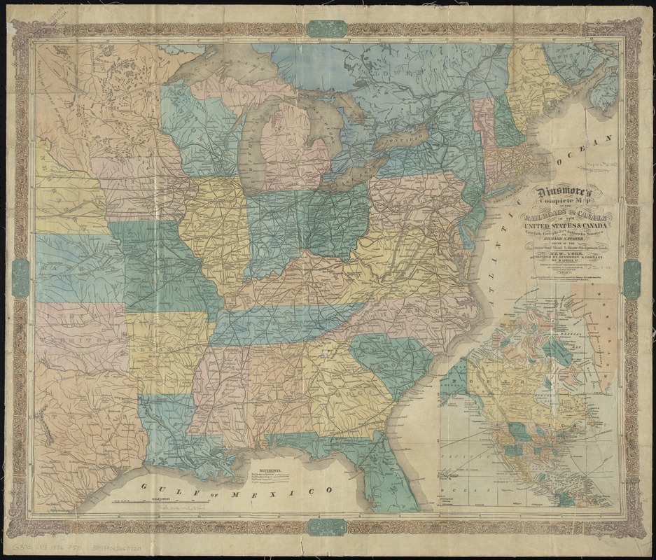
Dinsmore's complete map of the railroads & canals in the United States & Canada
Dinsmores complete map of the railroads & canals in the United States & Canada
×
Item Information
Title:
Dinsmore's complete map of the railroads & canals in the United States & Canada
Title (alt.):
Complete map of the railroads & canals in the United States & Canada
Creator:
Fisher, Richard Swainson.
Name on Item:
carefully compiled from authentic sources by Richard S. Fisher ; engraved ... by Schonberg & Co.
Date:
1856
Format:
Maps/Atlases
Location:
Boston Public Library
Norman B. Leventhal Map Center
Collection (local):
Norman B. Leventhal Map Center Collection
Subjects:
Railroads--United States--Maps
Railroads--Canada--Maps
Canals--United States--Maps
Canals--Canada--Maps
United States--Maps
Places:
United States
Canada
Extent:
1 map : col. ; 58 x 71 cm.
Permalink:
https://ark.digitalcommonwealth.org/ark:/50959/cj82m3280
Terms of Use:
No known copyright restrictions.
No known restrictions on use.
Publisher:
New York : Dinsmore & Co.
Scale:
Scale [ca. 1:4,000,000]
Language:
English
Notes:
Map of the eastern half of the United States and part of Canada showing drainage, state boundaries, and proposed, projected, and operating railroads.
Relief shown by hachures.
Prime meridians: New York and Greenwich.
Inset: [North America]
Identifier:
06_01_009181
Call #:
G3701.P3 1856 .F571
Barcode:
39999065660720
LCCN:
2003627014
show more...
View MODS XML
More Like This
Dinsmore's complete map of the railroads & canals in the United ...
Disturnell's new map of the United States and Canada showing all ...
Complete map of the rail roads and water courses in the United ...
Dinsmore's new railroad map of the United States and the Canadas, ...
Find More Like This >>
Tools
Share
Facebook
Pinterest
X
Reddit
Tumblr
Email
Copy link
Add to Folder
Questions/Comments
Cite This Item
IIIF Manifest
Downloads
Primary (full resolution, uncompressed)
(TIF, 203 MB)
Large (full resolution)
(JPEG, 17.1 MB)
Medium
(JPEG, 330 KB)