Skip to search
Skip to main content
Digital Commonwealth
Sign Up / Log In
Search for
Search
Search
Search
Basic
Advanced
Explore
Map
Collections
Institutions
Formats
For Educators
Primary Source Sets
Lesson Plans
Using Primary Sources
Searching Digital Commonwealth
For Institutions
Join Digital Commonwealth
Conferences, Trainings, & Events
How to Contribute Collections
Digitization Services
Board & Committees
Frequently Asked Questions
About
About Digital Commonwealth
News & Announcements
Copyright & Terms of Use
Harmful Content Statement
Partners
API
Contact Us
Boston Public Library
Norman B. Leventhal Map Center Collection
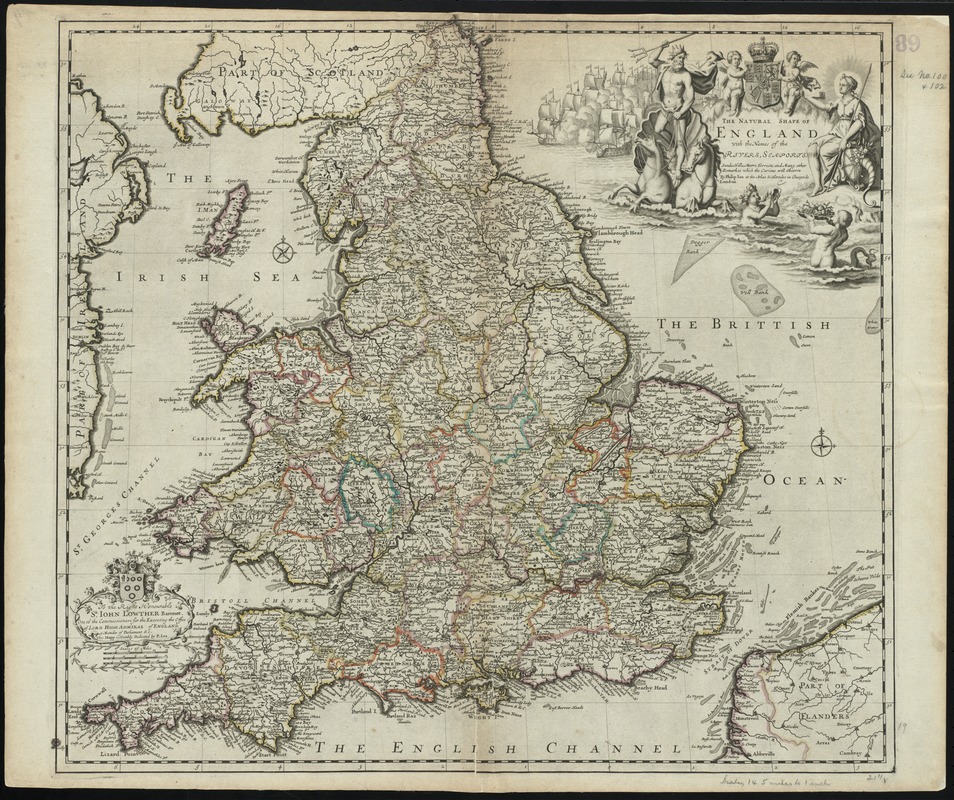
The natural shape of England with the names of rivers, seaports, sands, hills, moors, forrests, and many other remarks which the Curious will observe
The natural shape of England with the names of rivers, seaports, sands, hills, moors, forrests, and many other remarks which the Curious will observe
×
Item Information
Title:
The natural shape of England with the names of rivers, seaports, sands, hills, moors, forrests, and many other remarks which the Curious will observe
Title (alt.):
Collection of old maps
Creator:
Lea, Philip, fl. 1683-1700
Name on Item:
by Philip Lea.
Date:
[1690]
Format:
Maps/Atlases
Location:
Boston Public Library
Norman B. Leventhal Map Center
Collection (local):
Norman B. Leventhal Map Center Collection
Subjects:
England--Maps--Early works to 1800
Places:
England
Extent:
1 map : hand col. ; 50 x 56 cm.
Permalink:
https://ark.digitalcommonwealth.org/ark:/50959/cj82kz24w
Terms of Use:
No known copyright restrictions.
No known restrictions on use.
Publisher:
London : P. Lea
Scale:
Scale [ca. 1:1,260,000]
Language:
English
Notes:
Relief shown pictorially.
Cataloging, conservation, and digitization made possible in part by The National Endowment for the Humanities: Exploring the human endeavor.
Part of composite portfolio atlas with title "Collection of old maps."
Notes (date):
This date is inferred.
Identifier:
06_01_010026
Call #:
G1015 .C651 1630
Barcode:
30000003115220
show more...
View MODS XML
More Like This
An accurate map of England and Wales with the principal roads from ...
Anglesey : Wight Vectis olim ; Garnesay ; Iarsay
Anglia Regnum
Eboracum, Lincolnia, Derbia, Staffordia, Notinghamia, Lecestria, ...
Find More Like This >>
Tools
Share
Facebook
Pinterest
X
Reddit
Tumblr
Email
Copy link
Add to Folder
Questions/Comments
Cite This Item
IIIF Manifest
Downloads
Primary (full resolution, uncompressed)
(TIF, 145 MB)
Large (full resolution)
(JPEG, 12.2 MB)
Medium
(JPEG, 373 KB)