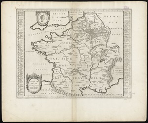
A new and exact map of France divided into all its provinces and acquisitions, according to the newest observations, and that accurate survey made by the King's command by Mr. Picar and de la Hire, with the post roads and the computed leagues from town to town, the passes of the Pirenean Mountains, and many other remarcks &c
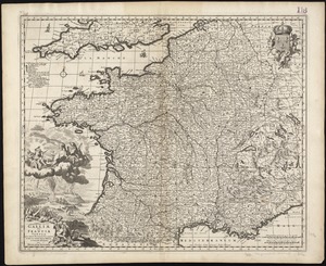
A new and exact map of France divided into all its provinces and acquisitions, according to the newest observations, and that accurate survey made by the Kings command by Mr. Picar and de la Hire, with the post roads and the computed leagues from town to town, the passes of the Pirenean Mountains, and many other remarcks &c
Item Information
Title:
A new and exact map of France divided into all its provinces and acquisitions, according to the newest observations, and that accurate survey made by the King's command by Mr. Picar and de la Hire, with the post roads and the computed leagues from town to town, the passes of the Pirenean Mountains, and many other remarcks &c
Relief shown pictorially.
Prime meridians: London and Ferro.
Includes index to towns and list of "ports or passes of the Pyrenean Mountains."
Appears in Moll's The world described, [1709-1736], plate 25.


![[Frantia]](https://bpldcassets.blob.core.windows.net/derivatives/images/commonwealth:7h14b063x/image_thumbnail_300.jpg)