Skip to search
Skip to main content
Digital Commonwealth
Sign Up / Log In
Search for
Search
Search
Search
Basic
Advanced
Explore
Map
Collections
Institutions
Formats
For Educators
Primary Source Sets
Lesson Plans
Using Primary Sources
Searching Digital Commonwealth
For Institutions
Join Digital Commonwealth
Conferences, Trainings, & Events
How to Contribute Collections
Digitization Services
Board & Committees
Frequently Asked Questions
About
About Digital Commonwealth
News & Announcements
Copyright & Terms of Use
Harmful Content Statement
Partners
API
Contact Us
Boston Public Library
Norman B. Leventhal Map Center Collection
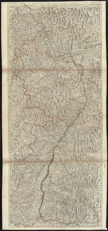
The seat of war on the Rhine being a new map of the course of that river from Basil to Bonn with the adjacent countries
The seat of war on the Rhine being a new map of the course of that river from Basil to Bonn with the adjacent countries
×
Item Information
Title:
The seat of war on the Rhine being a new map of the course of that river from Basil to Bonn with the adjacent countries
Creator:
L'Isle, Guillaume de, 1675-1726
Name on Item:
by Monsr. W. de L'Isle Geogr.
Date:
[1725]
Format:
Maps/Atlases
Location:
Boston Public Library
Norman B. Leventhal Map Center
Collection (local):
Norman B. Leventhal Map Center Collection
Subjects:
Rhine River--Maps--Early works to 1800
Germany--Maps--Early works to 1800
Places:
Germany
Rhine
(river)
Extent:
1 map : hand col. ; 138 x 58 cm.
Permalink:
https://ark.digitalcommonwealth.org/ark:/50959/cj82kt29f
Terms of Use:
No known copyright restrictions.
No known restrictions on use.
Publisher:
[London] : Printed for Thos. Bowles next the Chapter House in St. Pauls Church Yard & I. Bowles at ye Black Horse in Cornhill
Scale:
Scale [ca. 1:250,000]
Language:
English
Notes:
Relief shown pictorially.
Appears in Moll's The world described, [1709-1736], plate 22.
Notes (date):
This date is inferred.
Identifier:
06_01_009670
Call #:
G1015 .M65 1709
Barcode:
30000003877388
show more...
View MODS XML
More Like This
Circulus electorum Rheni sive Rhenanus Inferior complectens ...
Ducatus Meklenburgicus in quo sunt Ducatus Vandaliae et ...
Electoratus et Palatinatus Rheni Episcopatuum Spirensis et ...
Map of the Empire of Germany : including all the states ...
Find More Like This >>
Tools
Share
Facebook
Pinterest
X
Reddit
Tumblr
Email
Copy link
Add to Folder
Questions/Comments
Cite This Item
IIIF Manifest
Downloads
Primary (full resolution, uncompressed)
(TIF, 406 MB)
Large (full resolution)
(JPEG, 34.1 MB)
Medium
(JPEG, 173 KB)