Skip to search
Skip to main content
Digital Commonwealth
Sign Up / Log In
Search for
Search
Search
Search
Basic
Advanced
Explore
Map
Collections
Institutions
Formats
For Educators
Primary Source Sets
Lesson Plans
Using Primary Sources
Searching Digital Commonwealth
For Institutions
Join Digital Commonwealth
Conferences, Trainings, & Events
How to Contribute Collections
Digitization Services
Board & Committees
Frequently Asked Questions
About
About Digital Commonwealth
News & Announcements
Copyright & Terms of Use
Harmful Content Statement
Partners
API
Contact Us
Boston Public Library
Norman B. Leventhal Map Center Collection
/
Boston and New England Maps (Collection of Distinction)
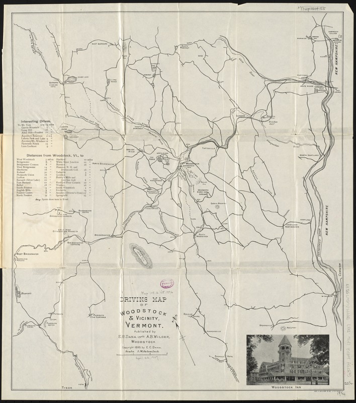
Driving map of Woodstock & vicinity, Vermont
Driving map of Woodstock & vicinity, Vermont
×
Item Information
Title:
Driving map of Woodstock & vicinity, Vermont
Title (alt.):
Road map of Woodstock, Vermont and vicinity
Creator:
Dana, E. C.
Date:
[ca. 1896]
Format:
Maps/Atlases
Location:
Boston Public Library
Norman B. Leventhal Map Center
Collection (local):
Norman B. Leventhal Map Center Collection
Subjects:
Roads--Vermont--Woodstock (Town)--Maps
Roads--Vermont--Maps
Woodstock (Vt. : Town)--Maps
Places:
Windsor (county)
>
Woodstock
Extent:
1 map ; 57 x 50 cm.
Permalink:
https://ark.digitalcommonwealth.org/ark:/50959/b8516243s
Terms of Use:
No known copyright restrictions.
No known restrictions on use.
Publisher:
Woodstock, Vt : E.C. Dana and A.B. Wilder
Scale:
Scale [1:63,360]. 1 mile to an inch
Language:
English
Notes:
Shows roads, railroads, towns, schools, cemeteries, hotels, and other points of interest.
Oriented with north to the upper left.
Relief shown by hachures.
Includes tables of "interesting drives" and distances, and photograph of the Woodstock Inn.
Identifier:
06_01_010599
Call #:
G3754.W9P2 1896 .D36
Barcode:
39999065675538
show more...
View MODS XML
More Like This
Lake Champlain streamline ferries : direct routes to Whiteface ...
Official highway map of the state of Vermont
Rand McNally official 1924 auto trails map Maine ; Rand McNally ...
The 100th anniversary map of Abraham Lincoln's visit to ...
Find More Like This >>
Tools
Share
Facebook
Pinterest
X
Reddit
Tumblr
Email
Copy link
Add to Folder
Questions/Comments
Cite This Item
IIIF Manifest
Downloads
Primary (full resolution, uncompressed)
(TIF, 141 MB)
Large (full resolution)
(JPEG, 11.9 MB)
Medium
(JPEG, 186 KB)