Skip to search
Skip to main content
Digital Commonwealth
Sign Up / Log In
Search for
Search
Search
Search
Basic
Advanced
Explore
Map
Collections
Institutions
Formats
For Educators
Primary Source Sets
Lesson Plans
Using Primary Sources
Searching Digital Commonwealth
For Institutions
Join Digital Commonwealth
Conferences, Trainings, & Events
How to Contribute Collections
Digitization Services
Board & Committees
Frequently Asked Questions
About
About Digital Commonwealth
News & Announcements
Copyright & Terms of Use
Harmful Content Statement
Partners
API
Contact Us
Boston Public Library
Norman B. Leventhal Map Center Collection
/
Boston and New England Maps (Collection of Distinction)
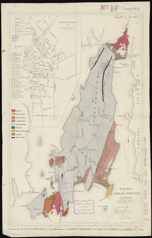
Road map of the island of Rhode Island, or Aquidneck
Road map of the island of Rhode Island, or Aquidneck
×
Item Information
Title:
Road map of the island of Rhode Island, or Aquidneck
Creator:
Hammett, Charles E. (Charles Edward), 1832-1902
Name on Item:
surveyed November, 1849 by Chas. E. Hammett Jr. ; drawn by Geo F. Turner.
Date:
1860
Format:
Maps/Atlases
Location:
Boston Public Library
Norman B. Leventhal Map Center
Collection (local):
Norman B. Leventhal Map Center Collection
Subjects:
Roads--Rhode Island--Rhode Island (Island)--Maps
Rhode Island (R.I. : Island)--Maps
Places:
Newport (county)
>
Rhode Island
(island)
Extent:
1 map : col. ; 39 x 25 cm.
Permalink:
https://ark.digitalcommonwealth.org/ark:/50959/b8516215m
Terms of Use:
No known copyright restrictions.
No known restrictions on use.
Publisher:
Newport, R.I.? : [City of Newport, R.I.]
Scale:
Scale [ca. 1:60,000]
Language:
English
Notes:
Shows geology.
Relief shown by hachures.
Inset: Plan of the town of Newport.
"Presented by the City of Newport, R.I., to the members of the American Association for the Advancement of Science, Aug. 1, 1860."
Identifier:
06_01_010567
Call #:
G3772.R5C5 1860 .H36
Barcode:
39999065675835
show more...
View MODS XML
More Like This
The 100th anniversary map of Abraham Lincoln's visit to ...
1630 shoreline
1879. Progress map of the U.S. Geographical Surveys west of the ...
1903 Map of Salem and surrounding places
Find More Like This >>
Tools
Share
Facebook
Pinterest
X
Reddit
Tumblr
Email
Copy link
Add to Folder
Questions/Comments
Cite This Item
IIIF Manifest
Downloads
Primary (full resolution, uncompressed)
(TIF, 45 MB)
Large (full resolution)
(JPEG, 3.78 MB)
Medium
(JPEG, 134 KB)