Skip to search
Skip to main content
Digital Commonwealth
Sign Up / Log In
Search for
Search
Search
Search
Basic
Advanced
Explore
Map
Collections
Institutions
Formats
For Educators
Primary Source Sets
Lesson Plans
Using Primary Sources
Searching Digital Commonwealth
For Institutions
Join Digital Commonwealth
Conferences, Trainings, & Events
How to Contribute Collections
Digitization Services
Board & Committees
Frequently Asked Questions
About
About Digital Commonwealth
News & Announcements
Copyright & Terms of Use
Harmful Content Statement
Partners
API
Contact Us
Boston Public Library
Norman B. Leventhal Map Center Collection
/
Urban Maps (Collection of Distinction)
/
Boston and New England Maps (Collection of Distinction)
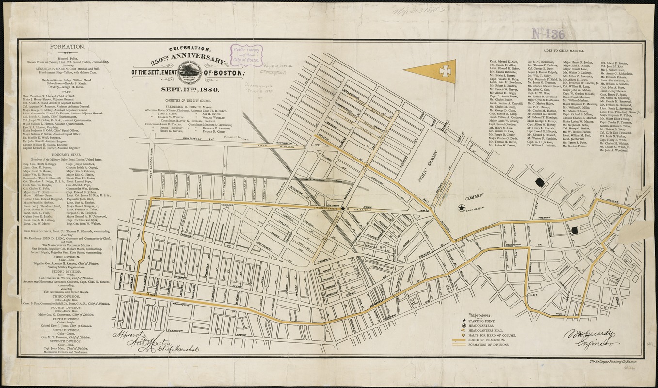
Celebration, 250th anniversary of the settlement of Boston, Sept. 17th, 1880
Celebration, 250th anniversary of the settlement of Boston, Sept. 17th, 1880
×
Item Information
Title:
Celebration, 250th anniversary of the settlement of Boston, Sept. 17th, 1880
Title (alt.):
250th anniversary of the settlement of Boston, Sept. 17th, 1880
Date:
[1880]
Format:
Maps/Atlases
Location:
Boston Public Library
Norman B. Leventhal Map Center
Collection (local):
Norman B. Leventhal Map Center Collection
Subjects:
Parades--Massachusetts--Boston--Maps
Boston (Mass.)--Centennial celebrations, etc--Maps
Places:
Suffolk (county)
>
Boston
Extent:
1 map : col. ; 38 x 75 cm.
Permalink:
https://ark.digitalcommonwealth.org/ark:/50959/9s161j611
Terms of Use:
No known copyright restrictions.
No known restrictions on use.
Publisher:
Boston : Heliotype Print. Co.
Scale:
Scale not given.
Language:
English
Notes:
Shows formation areas and parade route through the South End, Financial District and Back Bay.
Signed in ms.: "W.H. Cundy, engineer."
Includes lists of "Formation" and "Aides to Chief Marshal."
Notes (date):
This date is inferred.
Identifier:
06_01_004334
Call #:
G3764.B6E62 1880 .B67
Barcode:
39999059006245
show more...
View MODS XML
More Like This
Dedication of the Army and Navy Monument, Sept. 17, 1877
Plan showing the locality of the formation and the route of the ...
The 100th anniversary map of Abraham Lincoln's visit to ...
1630 shoreline
Find More Like This >>
Tools
Share
Facebook
Pinterest
X
Reddit
Tumblr
Email
Copy link
Add to Folder
Questions/Comments
Cite This Item
IIIF Manifest
Downloads
Primary (full resolution, uncompressed)
(TIF, 158 MB)
Large (full resolution)
(JPEG, 13.2 MB)
Medium
(JPEG, 404 KB)