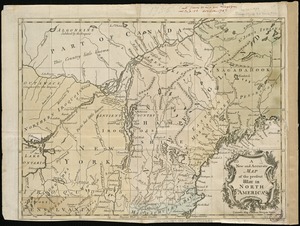
A general map of North America : in which is express'd the several new roads, forts, engagements, &c, taken from actual surveys and observations made in the army employ'd there, from the years 1754, to 1761
A general map of North America
Item Information
Title:
A general map of North America : in which is express'd the several new roads, forts, engagements, &c, taken from actual surveys and observations made in the army employ'd there, from the years 1754, to 1761
Title (alt.):
Cartes generales de l'Amérique Septentrionale : en les quelles sont exprimès les nouvelles routes, forts, batailles, &c. d'après les observations qui ou etè faites depuis l'an 1754, jusqu'a l'an 1761
Description:
Following her London-based husband John's death in 1762, Mary Ann Rocque administered his estate and carried on his map business for six years as the publisher of his works. This 1761 map of America published by "M.A. Rocque" was protected by an Act of Parliament, as it states under the bottom neatline, meaning that it was copyrighted and there were penalties for stealing the design and reusing it under another name. Mary Ann sometimes used her initials in the imprint, as on this map. Consequently, much of her work was unrecognized as that produced by a woman in the map trade.
Relief shown pictorially.
Identifies pre- and post-war boundaries.
Title in French and English.
Notes (date):
This date is inferred.
Notes (exhibitions):
Exhibited: "Women in Cartography: Five Centuries of Accomplishments" organized by the Norman B. Leventhal Map Center at the Boston Public Library, 2015-2016.