Skip to search
Skip to main content
Digital Commonwealth
Sign Up / Log In
Search for
Search
Search
Search
Basic
Advanced
Explore
Map
Collections
Institutions
Formats
For Educators
Primary Source Sets
Lesson Plans
Using Primary Sources
Searching Digital Commonwealth
For Institutions
Join Digital Commonwealth
Conferences, Trainings, & Events
How to Contribute Collections
Digitization Services
Board & Committees
Frequently Asked Questions
About
About Digital Commonwealth
News & Announcements
Copyright & Terms of Use
Harmful Content Statement
Partners
API
Contact Us
Boston Public Library
Norman B. Leventhal Map Center Collection
/
Urban Maps (Collection of Distinction)
/
Boston and New England Maps (Collection of Distinction)
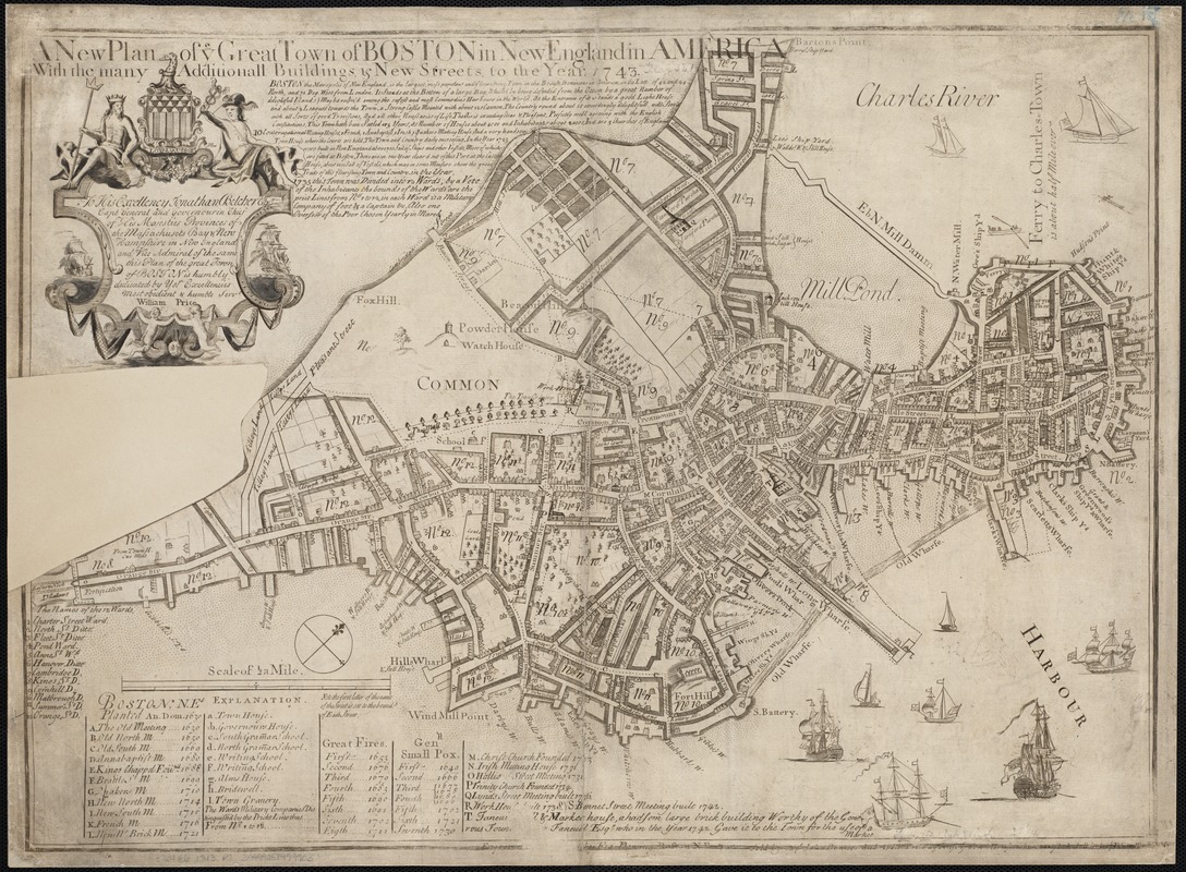
A new plan of ye great town of Boston in New England in America, with the many additionall buildings & new streets to the year 1743
A new plan of ye great town of Boston in New England in America, with the many additionall buildings & new streets to the year 1743
×
Item Information
Title:
A new plan of ye great town of Boston in New England in America, with the many additionall buildings & new streets to the year 1743
Creator:
Price, William, fl. 1725-1769
Date:
1743
Format:
Maps/Atlases
Location:
Boston Public Library
Norman B. Leventhal Map Center
Collection (local):
Norman B. Leventhal Map Center Collection
Subjects:
Boston (Mass.)--Maps--Early works to 1800
Places:
Suffolk (county)
>
Boston
Extent:
1 map ; 43 x 60 cm.
Permalink:
https://ark.digitalcommonwealth.org/ark:/50959/9s161952m
Terms of Use:
No known copyright restrictions.
No known restrictions on use.
Publisher:
Boston, Mass : Wm. Price
Edition:
7th state.
Scale:
Scale ca. 1:5,760.
Language:
English
Notes:
Oriented with north toward the upper right.
Includes text, ward index, and index to points of interest.
Identifier:
06_01_003262
Call #:
G3764.B6 1743 .P7
Barcode:
39999058999903
LCCN:
73691790
show more...
View MODS XML
More Like This
Boston
Boston, its environs and harbour, with the rebel works raised ...
Bowles's map of the seat of war in New England, comprehending the ...
Carte de la ville, baye et environs de Baston
Find More Like This >>
Tools
Share
Facebook
Pinterest
X
Reddit
Tumblr
Email
Copy link
Add to Folder
Questions/Comments
Cite This Item
IIIF Manifest
Downloads
Primary (full resolution, uncompressed)
(TIF, 172 MB)
Large (full resolution)
(JPEG, 14.5 MB)
Medium
(JPEG, 386 KB)
GeoTIFF (georeferenced)
(TIF, 185 MB)