Skip to search
Skip to main content
Digital Commonwealth
Sign Up / Log In
Search for
Search
Search
Search
Basic
Advanced
Explore
Map
Collections
Institutions
Formats
For Educators
Primary Source Sets
Lesson Plans
Using Primary Sources
Searching Digital Commonwealth
For Institutions
Join Digital Commonwealth
Conferences, Trainings, & Events
How to Contribute Collections
Digitization Services
Board & Committees
Frequently Asked Questions
About
About Digital Commonwealth
News & Announcements
Copyright & Terms of Use
Harmful Content Statement
Partners
API
Contact Us
Boston Public Library
Norman B. Leventhal Map Center Collection
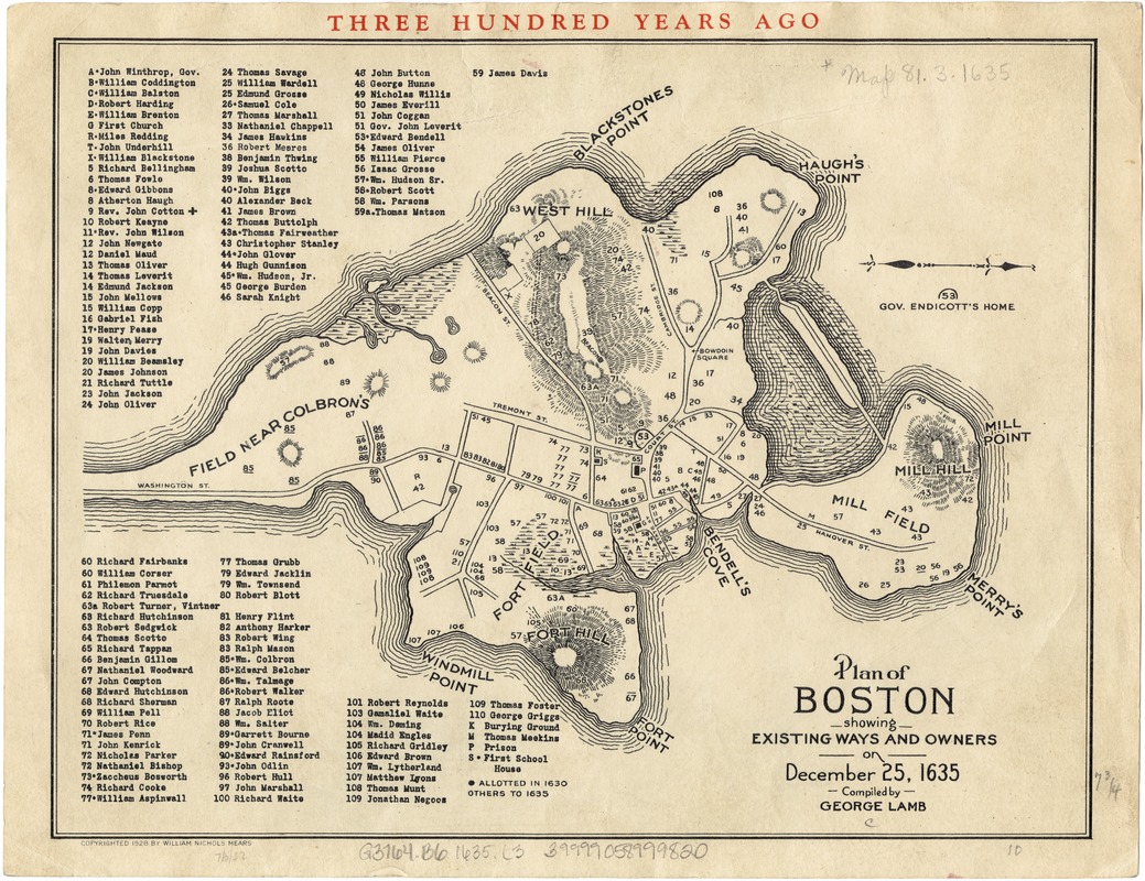
Plan of Boston showing existing ways and owners on December 25, 1635
Plan of Boston showing existing ways and owners on December 25, 1635
×
Item Information
Title:
Plan of Boston showing existing ways and owners on December 25, 1635
Creator:
Lamb, George.
Name on Item:
compiled by George Lamb.
Date:
[ca. 1928]
Format:
Maps/Atlases
Location:
Boston Public Library
Norman B. Leventhal Map Center
Collection (local):
Norman B. Leventhal Map Center Collection
Subjects:
Homeowners--Massachusetts--Boston--Maps
Landowners--Massachusetts--Boston--Maps
Boston (Mass.)--History--Colonial period, ca. 1600-1775--Maps
Places:
Suffolk (county)
>
Boston
Extent:
1 plan ; 20 x 25 cm.
Permalink:
https://ark.digitalcommonwealth.org/ark:/50959/9s161947r
Terms of Use:
No known copyright restrictions.
No known restrictions on use.
Publisher:
S.l : [William Nichols Mears]
Scale:
Scale not given.
Language:
English
Notes:
Oriented with north to the right.
Relief shown by hachures.
Includes index to names of landowners.
Identifier:
06_01_003256
Call #:
G3764.B6 1635 .L3
Barcode:
39999058999820
show more...
View MODS XML
More Like This
Plan of Boston showing existing ways and owners on December 25, 1630
Plan of Boston showing existing ways and owners on December 25, 1635
Plan of Boston showing existing ways and owners on December 25, 1635
Plan of Boston showing existing ways and owners on December 25, 1640
Find More Like This >>
Tools
Share
Facebook
Pinterest
X
Reddit
Tumblr
Email
Copy link
Add to Folder
Questions/Comments
Cite This Item
IIIF Manifest
Downloads
Primary (full resolution, uncompressed)
(TIF, 96.7 MB)
Large (full resolution)
(JPEG, 8.12 MB)
Medium
(JPEG, 378 KB)
GeoTIFF (georeferenced)
(TIF, 111 MB)