Boston Public LibraryNorman B. Leventhal Map Center Collection / American Revolutionary War-Era Maps (Collection of Distinction) / Maritime Charts and Atlases (Collection of Distinction)
Halifax Harbour ... Catch Harbour ... small vessels only
Item Information
- Title:
- Halifax Harbour ... Catch Harbour ... small vessels only
- Description:
-
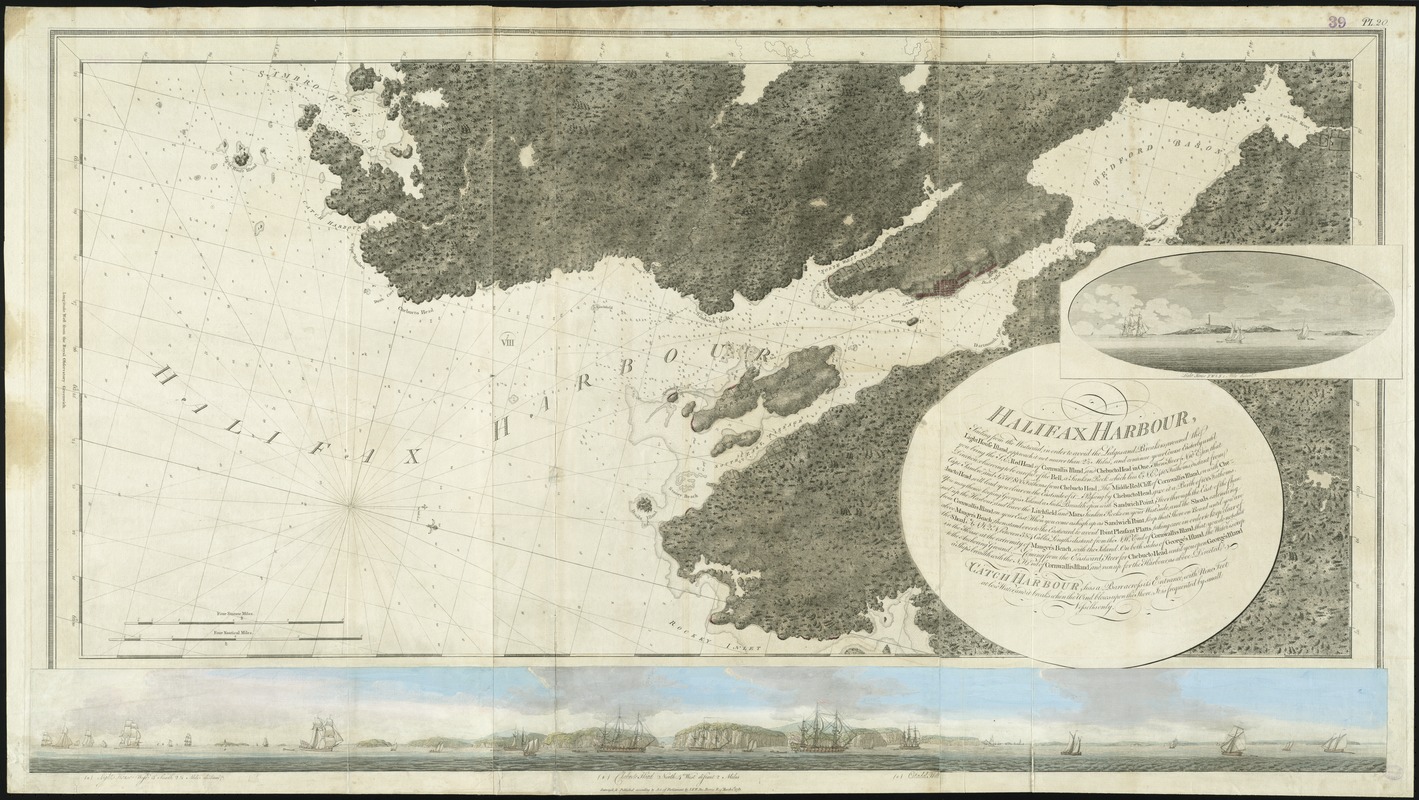
The colorful and beautifully executed panoramic view at the bottom of this chart depicts the coastal region near Halifax. Designed to provide navigators with an accurate view of the shoreline and Harbour, this coastal profile extends from the Sambro Island Lighthouse, past Chebucto Head, north to the inner Harbour of Halifax. Included is a distant view of the citadel in Halifax, a fortress originally built by the British in 1749 to protect the town from the French settlers in Louisbourg.
- Creator:
- Des Barres, Joseph F. W. (Joseph Frederick Wallet), 1722-1824
- Name on Item:
-
survey'd, & published according to Act of Parliament by J.F.W. Des Barres Esqr.
- Date:
-
1781
- Format:
-
Maps/Atlases
- Location:
-
Boston Public Library
Norman B. Leventhal Map Center - Collection (local):
-
Norman B. Leventhal Map Center Collection
- Subjects:
-
Nautical charts--Nova Scotia--Bedford Bay--Early works to 1800
Nautical charts--Nova Scotia--Halifax Harbour--Early works to 1800
Nautical charts--Nova Scotia--Early works to 1800
Coasts--Nova Scotia--Maps--Early works to 1800
Halifax Harbour (N.S.)--Maps--Early works to 1800
Bedford Bay (N.S.)--Maps--Early works to 1800
Nova Scotia--Maps--Early works to 1800
- Places:
-
Canada > Nova Scotia (province) > Halifax Harbour (harbor)
Bedford Bay
- Extent:
- 1 chart : hand col. ; 62 x 128 cm, on sheet 79 x 151 cm.
- Permalink:
- https://ark.digitalcommonwealth.org/ark:/50959/9g54xm206
- Terms of Use:
-
No known copyright restrictions.
No known restrictions on use.
- Publisher:
-
[London] :
survey'd, & published according to Act of Parliament by J.F.W. Des Barres Esqr
- Edition:
- 7th state.
- Scale:
-
Scale [ca. 1:30,000]
- Language:
-
English
- Notes:
-
Chart of the area from Cole Harbor to Sambro Harbor, and inland to the head of Bedford Basin.
Relief shown by shading. Depths shown by soundings.
Oriented with north toward the lower right.
In upper margin: "PL. 20."
Insets: Light house S.E. one mile distant ; [Panorama of the entrance to Halifax Harbor].
Appears in the author's Atlantic Neptune. London : J.F.W. Des Barres, 1777-[1781].
- Notes (exhibitions):
-
Exhibited: "Charting an Empire: The Atlantic Neptune" organized by the Norman B. Leventhal Map Center at the Boston Public Library, 2013.
- Identifier:
-
06_01_008279
- Call #:
-
G1106.P5 D47 1777
- Barcode:
-
30000003797525
Downloads
- Primary (full resolution, uncompressed)(TIF, 213 MB)
- Large (full resolution)(JPEG, 17.9 MB)
- Medium(JPEG, 391 KB)