Skip to search
Skip to main content
Digital Commonwealth
Sign Up / Log In
Search for
Search
Search
Search
Basic
Advanced
Explore
Map
Collections
Institutions
Formats
For Educators
Primary Source Sets
Lesson Plans
Using Primary Sources
Searching Digital Commonwealth
For Institutions
Join Digital Commonwealth
Conferences, Trainings, & Events
How to Contribute Collections
Digitization Services
Board & Committees
Frequently Asked Questions
About
About Digital Commonwealth
News & Announcements
Copyright & Terms of Use
Harmful Content Statement
Partners
API
Contact Us
Boston Public Library
Norman B. Leventhal Map Center Collection
/
American Revolutionary War-Era Maps (Collection of Distinction)
/
Maritime Charts and Atlases (Collection of Distinction)
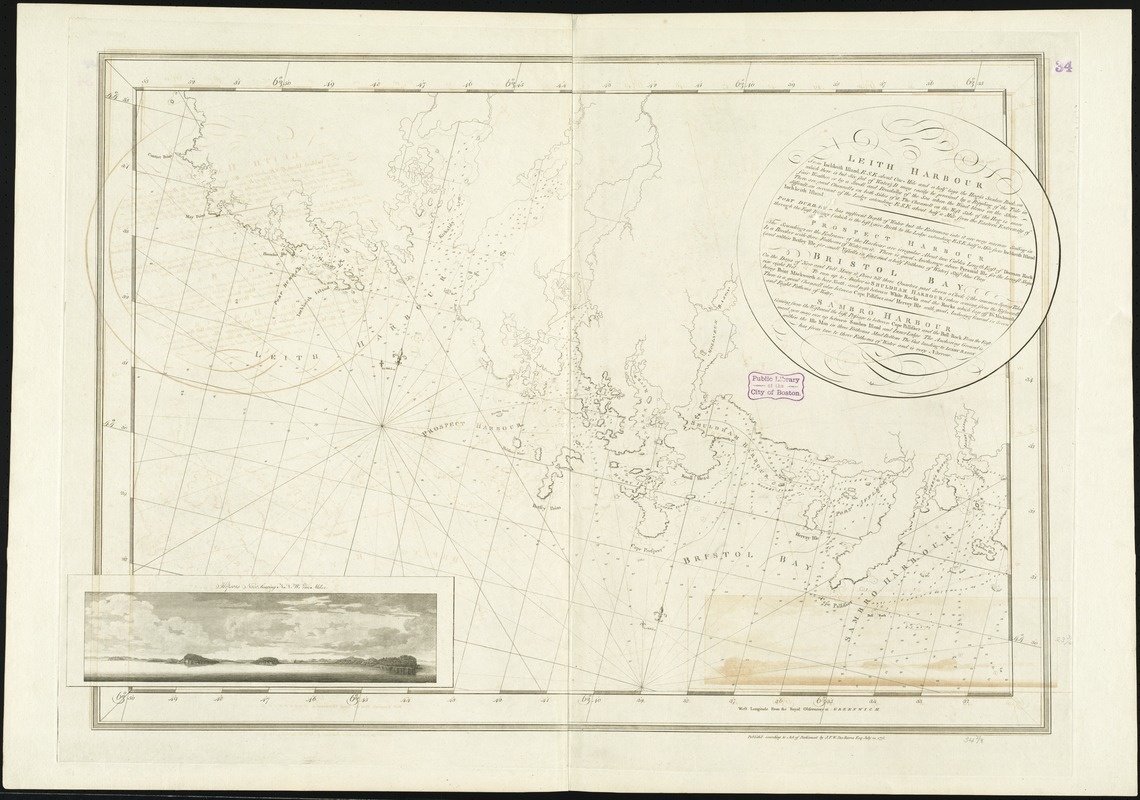
Leith Harbour ... : Prospect Harbour ... Bristol Bay ... Sambro Harbour
Leith Harbour ...
×
Item Information
Title:
Leith Harbour ... : Prospect Harbour ... Bristol Bay ... Sambro Harbour
Creator:
Des Barres, Joseph F. W. (Joseph Frederick Wallet), 1722-1824
Date:
1775
Format:
Maps/Atlases
Location:
Boston Public Library
Norman B. Leventhal Map Center
Collection (local):
Norman B. Leventhal Map Center Collection
Subjects:
Nautical charts--Nova Scotia--Early works to 1800
Coasts--Nova Scotia--Maps--Early works to 1800
Nova Scotia--Maps--Early works to 1800
Places:
Canada
>
Nova Scotia
(province)
Extent:
1 chart ; 60 x 88 cm.
Permalink:
https://ark.digitalcommonwealth.org/ark:/50959/9g54xm10z
Terms of Use:
No known copyright restrictions.
No known restrictions on use.
Publisher:
[London] : J.F.W. Des Barres
Edition:
1st state.
Scale:
Scale [ca. 1:28,000]
Language:
English
Notes:
Chart of the southeast coast of Nova Scotia, from Cape Sambro to St. Margaret's Bay.
Depths shown by soundings.
Oriented with north toward the upper right.
Appears in the author's Atlantic Neptune. London : J.F.W. Des Barres, 1777-[1781].
Identifier:
06_01_008254
Call #:
G1106.P5 D47 1777
Barcode:
30000003794971
show more...
View MODS XML
More Like This
Canso Harbor
Conway Harbour : Port Aylesbury
Crow Harbour : on the south shore of Chedabuctou Bay
Egmont Harbor
Find More Like This >>
Tools
Share
Facebook
Pinterest
X
Reddit
Tumblr
Email
Copy link
Add to Folder
Questions/Comments
Cite This Item
IIIF Manifest
Downloads
Primary (full resolution, uncompressed)
(TIF, 244 MB)
Large (full resolution)
(JPEG, 20.5 MB)
Medium
(JPEG, 250 KB)