Skip to search
Skip to main content
Digital Commonwealth
Sign Up / Log In
Search for
Search
Search
Search
Basic
Advanced
Explore
Map
Collections
Institutions
Formats
For Educators
Primary Source Sets
Lesson Plans
Using Primary Sources
Searching Digital Commonwealth
For Institutions
Join Digital Commonwealth
Conferences, Trainings, & Events
How to Contribute Collections
Digitization Services
Board & Committees
Frequently Asked Questions
About
About Digital Commonwealth
News & Announcements
Copyright & Terms of Use
Harmful Content Statement
Partners
API
Contact Us
Boston Public Library
Norman B. Leventhal Map Center Collection
Boston Harbor
Boston Harbor
×
Item Information
Title:
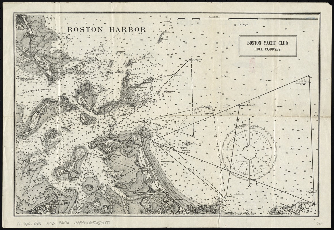
Boston Harbor
Title (alt.):
Boston Yacht Club Hull courses
Creator:
Boston Yacht Club
Name on Item:
Boston Yacht Club.
Date:
[1903]
Format:
Maps/Atlases
Location:
Boston Public Library
Norman B. Leventhal Map Center
Collection (local):
Norman B. Leventhal Map Center Collection
Subjects:
Nautical charts--Massachusetts--Boston Bay
Nautical charts--Massachusetts--Boston Harbor
Places:
Boston Harbor
Extent:
1 map ; 25 x 38 cm.
Permalink:
https://ark.digitalcommonwealth.org/ark:/50959/9g54xk40g
Terms of Use:
No known copyright restrictions.
No known restrictions on use.
Publisher:
Boston : Boston Yacht Club
Scale:
Scale [ca. 1:52,000]
Language:
English
Notes:
Relief shown by contours. Depths shown by soundings.
Shows course for the open race on June 17, 1903.
Text on verso.
Notes (date):
This date is inferred.
Identifier:
06_01_008056
Call #:
G3762.B65 1903 .B67x
Barcode:
39999065650077
show more...
View MODS XML
More Like This
Boston Harbor, Massachusetts
Boston Harbor, Massachusetts
Eldridge's new chart of Boston Harbor : compiled from the latest ...
New chart of Boston Harbor
Find More Like This >>
Tools
Share
Facebook
Pinterest
X
Reddit
Tumblr
Email
Copy link
Add to Folder
Questions/Comments
Cite This Item
IIIF Manifest
Downloads
Primary (full resolution, uncompressed)
(TIF, 37.1 MB)
Large (full resolution)
(JPEG, 3.11 MB)
Medium
(JPEG, 389 KB)