Skip to search
Skip to main content
Digital Commonwealth
Sign Up / Log In
Search for
Search
Search
Search
Basic
Advanced
Explore
Map
Collections
Institutions
Formats
For Educators
Primary Source Sets
Lesson Plans
Using Primary Sources
Searching Digital Commonwealth
For Institutions
Join Digital Commonwealth
Conferences, Trainings, & Events
How to Contribute Collections
Digitization Services
Board & Committees
Frequently Asked Questions
About
About Digital Commonwealth
News & Announcements
Copyright & Terms of Use
Harmful Content Statement
Partners
API
Contact Us
Boston Public Library
Norman B. Leventhal Map Center Collection
/
Urban Maps (Collection of Distinction)
/
Boston and New England Maps (Collection of Distinction)
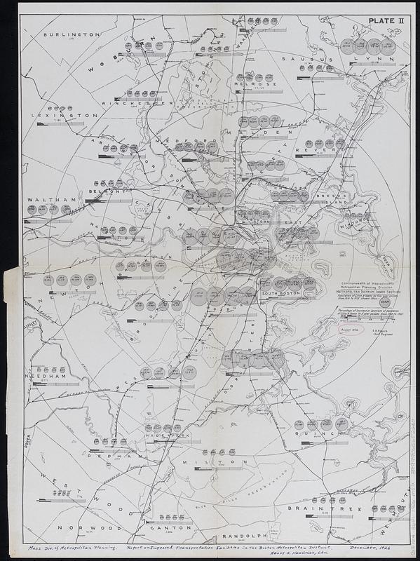
Metropolitan district - inner section : population of cities & towns by five year periods from 1910 to 1925
Metropolitan district - inner section
×
Item Information
Title:
Metropolitan district - inner section : population of cities & towns by five year periods from 1910 to 1925
Publisher:
Massachusetts. Division of Metropolitan Planning
Date:
1926
Format:
Maps/Atlases
Location:
Boston Public Library
Norman B. Leventhal Map Center
Collection (local):
Norman B. Leventhal Map Center Collection
Subjects:
Boston (Mass.)--Population--Maps
Transportation--Massachusetts--Boston--Maps
Railroads--Massachusetts--Boston--Maps
Places:
Suffolk (county)
>
Boston
Extent:
1 map ; 50 x 37 cm
Permalink:
https://ark.digitalcommonwealth.org/ark:/50959/8336kq65q
Terms of Use:
No known copyright restrictions.
No known restrictions on use.
Publisher:
[Boston, Mass.] : [Division of Metropolitan Planning]
Scale:
Scale approximately 1:67,000
Language:
English
Notes:
Shows radial distances from Boston.
From Report on improved transportation facilities in the Boston metropolitan district.
Identifier:
06_01_018328
Call #:
G3764.B6P1 1926 .M37x
Barcode:
39999065652230
show more...
View MODS XML
More Like This
Change in white population (non-Hispanic), 2010 to 2018
Map of Massachusetts showing population according to census of 1910
Massachusetts Bay Transportation Authority
Map of Boston inner harbor to accompany report under chapter 93, ...
Find More Like This >>
Tools
Share
Facebook
Pinterest
X
Reddit
Tumblr
Email
Copy link
Add to Folder
Questions/Comments
Cite This Item
IIIF Manifest
Downloads
Primary (full resolution, uncompressed)
(TIF, 84.2 MB)
Large (full resolution)
(JPEG, 7.07 MB)
Medium
(JPEG, 120 KB)