Skip to search
Skip to main content
Digital Commonwealth
Sign Up / Log In
Search for
Search
Search
Search
Basic
Advanced
Explore
Map
Collections
Institutions
Formats
For Educators
Primary Source Sets
Lesson Plans
Using Primary Sources
Searching Digital Commonwealth
For Institutions
Join Digital Commonwealth
Conferences, Trainings, & Events
How to Contribute Collections
Digitization Services
Board & Committees
Frequently Asked Questions
About
About Digital Commonwealth
News & Announcements
Copyright & Terms of Use
Harmful Content Statement
Partners
API
Contact Us
Boston Public Library
Norman B. Leventhal Map Center Collection
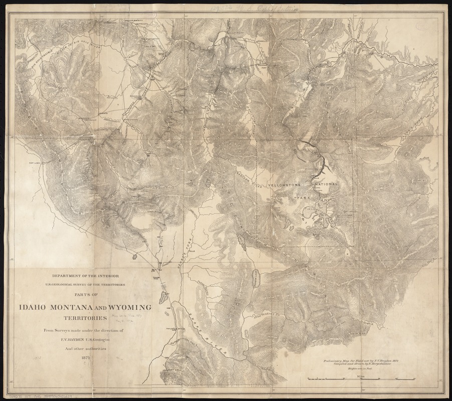
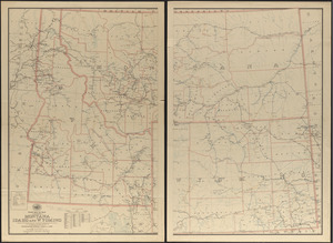
Parts of Idaho, Montana and Wyoming territories
Parts of Idaho, Montana and Wyoming territories
×
Item Information
Title:
Parts of Idaho, Montana and Wyoming territories
Creator:
Geological Survey of the Territories (U.S.)
Name on Item:
from surveys made under the direction of F.V. Hayden and other authorities ; compiled and drawn by E. Hergesheimer.
Date:
1871
Format:
Maps/Atlases
Location:
Boston Public Library
Norman B. Leventhal Map Center
Collection (local):
Norman B. Leventhal Map Center Collection
Subjects:
Hydrology--Idaho--Maps
Hydrology--Montana--Maps
Hydrology--Wyoming--Maps
Idaho--Maps
Montana--Maps
Wyoming--Maps
Places:
Idaho
Montana
Wyoming
Extent:
1 map ; 54 x 61 cm.
Permalink:
https://ark.digitalcommonwealth.org/ark:/50959/7h14b2002
Terms of Use:
No known copyright restrictions.
No known restrictions on use.
Publisher:
[Washington, D.C.] : Dept. of the Interior, U.S. Geological Survey of the Territories
Scale:
Scale [ca. 1:633,600]
Language:
English
Notes:
Relief shown by hachures and spot heights.
"Preliminary map for field use by F.V. Hayden 1872."
Identifier:
06_01_008717
Call #:
G4270 1871 .G46
Barcode:
39999065656629
show more...
View MODS XML
More Like This
Post route map of the states of Montana, Idaho and Wyoming showing ...
Post route map of the states of Montana, Idaho and Wyoming with ...
Post route map of the states of Montana, Idaho and Wyoming with ...
Post route map of the territories of Montana, Idaho, and Wyoming ...
Find More Like This >>
Tools
Share
Facebook
Pinterest
X
Reddit
Tumblr
Email
Copy link
Add to Folder
Questions/Comments
Cite This Item
IIIF Manifest
Downloads
Primary (full resolution, uncompressed)
(TIF, 94.9 MB)
Large (full resolution)
(JPEG, 7.97 MB)
Medium
(JPEG, 293 KB)