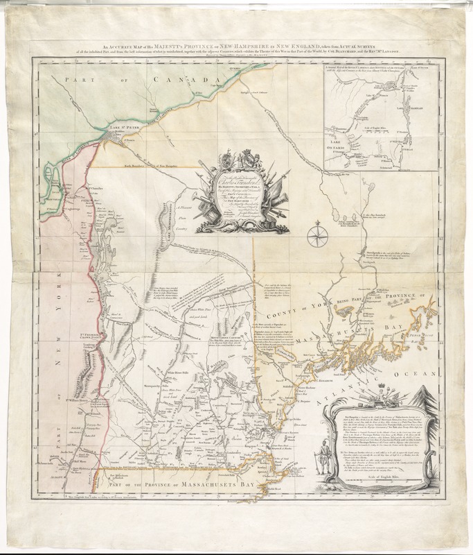
An accurate map of His Majesty's province of New-Hampshire in New England : taken from actual surveys of all the inhabited part, and from the best information of what is uninhabited, together with the adjacent countries, which exhibits the theatre of this war in that part of the world
Item Information
- Title:
- An accurate map of His Majesty's province of New-Hampshire in New England : taken from actual surveys of all the inhabited part, and from the best information of what is uninhabited, together with the adjacent countries, which exhibits the theatre of this war in that part of the world
- Creator:
- Blanchard, Joseph, d. 1758
- Name on Item:
-
by Col. Blanchard and the Revd. Mr. Langdon ; engraved by Thomas Jefferys, geographer to His Majesty.
- Date:
-
1761
- Format:
-
Maps/Atlases
- Location:
- George Washington's Mount Vernon
- Collection (local):
-
Richard H. Brown Revolutionary War Map Collection at Mount Vernon
- Subjects:
-
United States--History--French and Indian War, 1754-1763
New Hampshire--Administrative and political divisions--Maps--Early works to 1800
Vermont--Administrative and political divisions--Maps--Early works to 1800
Maine--Administrative and political divisions--Maps--Early works to 1800
Townshend, Charles, 1725-1767
- Places:
-
Maine
Vermont
New Hampshire
- Extent:
- 1 map on 2 sheets : hand col. ; 71 x 66 cm., on sheets 56 x 74 cm.
- Permalink:
- https://ark.digitalcommonwealth.org/ark:/50959/7h149z66c
- Terms of Use:
-
No known copyright restrictions.
This work is licensed for use under a Creative Commons Attribution Non-Commercial Share Alike License (CC BY-NC-SA).