Skip to search
Skip to main content
Digital Commonwealth
Sign Up / Log In
Search for
Search
Search
Search
Basic
Advanced
Explore
Map
Collections
Institutions
Formats
For Educators
Primary Source Sets
Lesson Plans
Using Primary Sources
Searching Digital Commonwealth
For Institutions
Join Digital Commonwealth
Conferences, Trainings, & Events
How to Contribute Collections
Digitization Services
Board & Committees
Frequently Asked Questions
About
About Digital Commonwealth
News & Announcements
Copyright & Terms of Use
Harmful Content Statement
Partners
API
Contact Us
Boston Public Library
Norman B. Leventhal Map Center Collection
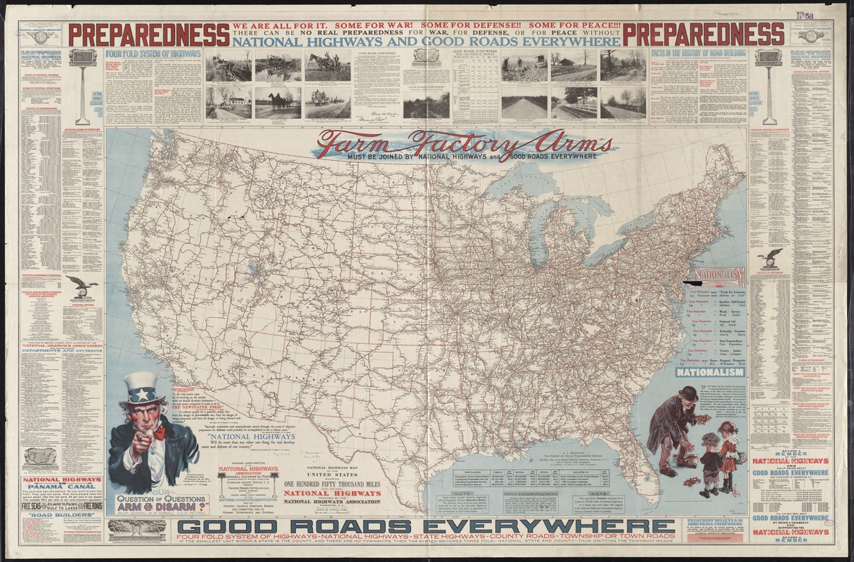
National highways map of the United States showing one hundred fifty thousand miles of national highways proposed by the National Highways Association
National highways map of the United States showing one hundred fifty thousand miles of national highways proposed by the National Highways Association
×
Item Information
Title:
National highways map of the United States showing one hundred fifty thousand miles of national highways proposed by the National Highways Association
Creator:
Mulford, John C.
Name on Item:
John C. Mulford, chief cartographer, G.E. Lombard, J.M. Darley, E.E. Jenkins, cartographers ; published under direction of the National Highways Association.
Date:
1918
Format:
Maps/Atlases
Location:
Boston Public Library
Norman B. Leventhal Map Center
Collection (local):
Norman B. Leventhal Map Center Collection
Subjects:
Roads--United States--Maps
Places:
Extent:
1 map : col. ; 76 x 125 cm., on sheet 102 x 157 cm.
Permalink:
https://ark.digitalcommonwealth.org/ark:/50959/7h149z343
Terms of Use:
No known copyright restrictions.
No known restrictions on use.
Publisher:
Washington, D.C : National Highways Association
Scale:
Scale [ca. 1:3,800,000]
Language:
English
Notes:
Text and ill. in margins.
Identifier:
06_01_008597
Call #:
G3701.P2 1918 .M35
Barcode:
39999065655068
show more...
View MODS XML
More Like This
Broadway of America an all year ... all weather comfortable route ...
Hammond's comprehensive map of the United States with portions of ...
Hammond's comprehensive map of the United States with portions of ...
National highways map of the United States showing one hundred ...
Find More Like This >>
Tools
Share
Facebook
Pinterest
X
Reddit
Tumblr
Email
Copy link
Add to Folder
Questions/Comments
Cite This Item
IIIF Manifest
Downloads
Primary (full resolution, uncompressed)
(TIF, 412 MB)
Large (full resolution)
(JPEG, 34.6 MB)
Medium
(JPEG, 451 KB)