Skip to search
Skip to main content
Digital Commonwealth
Sign Up / Log In
Search for
Search
Search
Search
Basic
Advanced
Explore
Map
Collections
Institutions
Formats
For Educators
Primary Source Sets
Lesson Plans
Using Primary Sources
Searching Digital Commonwealth
For Institutions
Join Digital Commonwealth
Conferences, Trainings, & Events
How to Contribute Collections
Digitization Services
Board & Committees
Frequently Asked Questions
About
About Digital Commonwealth
News & Announcements
Copyright & Terms of Use
Harmful Content Statement
Partners
API
Contact Us
Boston Public Library
Norman B. Leventhal Map Center Collection
/
Boston and New England Maps (Collection of Distinction)
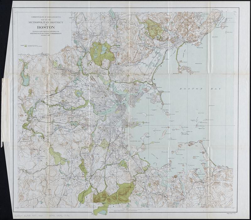
Map of the metropolitan district of Boston : showing local public reservations, and holdings of the Metropolitan Park Commission, December 1, 1907
Map of the metropolitan district of Boston
×
Item Information
Title:
Map of the metropolitan district of Boston : showing local public reservations, and holdings of the Metropolitan Park Commission, December 1, 1907
Cartographer:
Massachusetts. Metropolitan Park Commission
Date:
1908
Format:
Maps/Atlases
Location:
Boston Public Library
Norman B. Leventhal Map Center
Collection (local):
Norman B. Leventhal Map Center Collection
Subjects:
Boston Metropolitan Area (Mass.)--Maps
Parks--Massachusetts--Boston Metropolitan Area--Maps
Protected areas--Massachusetts--Boston Metropolitan Area--Maps
Open spaces--Massachusetts--Boston Metropolitan Area--Maps
Public lands--Massachusetts--Boston Metropolitan Area--Maps
Places:
Suffolk (county)
>
Boston
Extent:
1 map : color ; 61 x 63 cm
Permalink:
https://ark.digitalcommonwealth.org/ark:/50959/6t056522n
Terms of Use:
No known copyright restrictions.
No known restrictions on use.
Publisher:
[Boston] : [Wright & Potter Printing Co.]
Scale:
Scale 1:62,500
Language:
English
Notes:
Relief shown by contours.
Detached from Report of the Board of Metropolitan Park Commissioners (Boston : Wright & Potter Printing Co., 1908).
Identifier:
06_01_018357
Call #:
G3764.B6G5 1907 .M37
Barcode:
39999085967196
show more...
View MODS XML
More Like This
Road map of the Boston district showing the metropolitan park system.
Map of the Metropolitan District of Boston showing local public ...
Bay State Street Ry. Co's lines and connections
Boston personal income ; Boston personal income [and] residential ...
Find More Like This >>
Tools
Share
Facebook
Pinterest
X
Reddit
Tumblr
Email
Copy link
Add to Folder
Questions/Comments
Cite This Item
IIIF Manifest
Downloads
Primary (full resolution, uncompressed)
(TIF, 175 MB)
Large (full resolution)
(JPEG, 14.7 MB)
Medium
(JPEG, 130 KB)


![Boston personal income ; Boston personal income [and] residential population density](https://bpldcassets.blob.core.windows.net/derivatives/images/commonwealth:fn107c409/image_thumbnail_300.jpg)