Skip to search
Skip to main content
Digital Commonwealth
Sign Up / Log In
Search for
Search
Search
Search
Basic
Advanced
Explore
Map
Collections
Institutions
Formats
For Educators
Primary Source Sets
Lesson Plans
Using Primary Sources
Searching Digital Commonwealth
For Institutions
Join Digital Commonwealth
Conferences, Trainings, & Events
How to Contribute Collections
Digitization Services
Board & Committees
Frequently Asked Questions
About
About Digital Commonwealth
News & Announcements
Copyright & Terms of Use
Harmful Content Statement
Partners
API
Contact Us
Boston Public Library
Norman B. Leventhal Map Center Collection
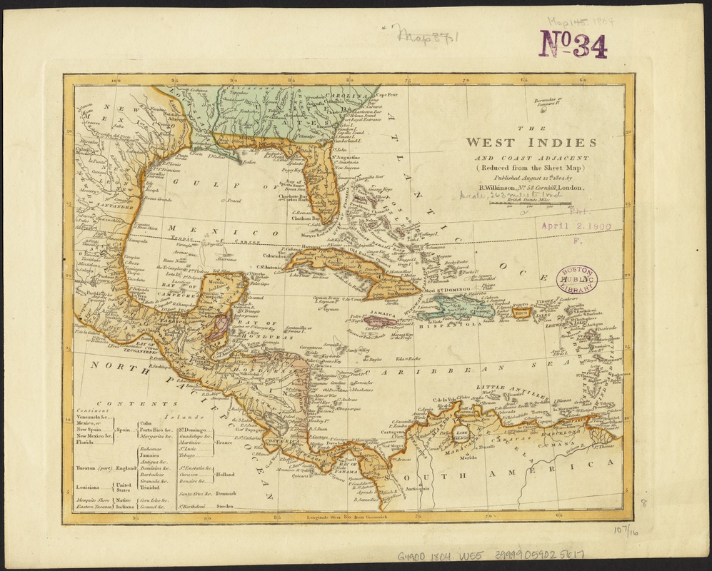
The West Indies and coast adjacent : reduced from the sheet map
The West Indies and coast adjacent
×
Item Information
Title:
The West Indies and coast adjacent : reduced from the sheet map
Creator:
Wilkinson, Robert, d. ca. 1825
Date:
1804
Format:
Maps/Atlases
Location:
Boston Public Library
Norman B. Leventhal Map Center
Collection (local):
Norman B. Leventhal Map Center Collection
Subjects:
West Indies--Maps--Early works to 1800
Places:
West Indies
Extent:
1 map : col. ; 21 x 27 cm.
Permalink:
https://ark.digitalcommonwealth.org/ark:/50959/6t053s00t
Terms of Use:
No known copyright restrictions.
No known restrictions on use.
Publisher:
London : R. Wilkinson
Scale:
Scale 1:16,663,680.
Language:
English
Notes:
Published August 12th 1804.
Cataloging, conservation, and digitization made possible in part by The National Endowment for the Humanities: Exploring the human endeavor.
Identifier:
06_01_006432
Call #:
G4900 1804 .W55
Barcode:
39999059025617
show more...
View MODS XML
More Like This
[Alleen de Caribische Eilanden, vervat in 't groot]
Beschryvinghe der eylanden van Cuba, Hispaniola, Iamaica, S. ...
Carta esferica que comprende una parta de las Islas Antillas, las ...
Carta particolare dell' Isola di Bermuda sin all' India ...
Find More Like This >>
Tools
Share
Facebook
Pinterest
X
Reddit
Tumblr
Email
Copy link
Add to Folder
Questions/Comments
Cite This Item
IIIF Manifest
Downloads
Primary (full resolution, uncompressed)
(TIF, 152 MB)
Large (full resolution)
(JPEG, 12.8 MB)
Medium
(JPEG, 284 KB)
GeoTIFF (georeferenced)
(TIF, 178 MB)
![[Alleen de Caribische Eilanden, vervat in 't groot]](https://bpldcassets.blob.core.windows.net/derivatives/images/commonwealth:st74cw59p/image_thumbnail_300.jpg)


