Skip to search
Skip to main content
Digital Commonwealth
Sign Up / Log In
Search for
Search
Search
Search
Basic
Advanced
Explore
Map
Collections
Institutions
Formats
For Educators
Primary Source Sets
Lesson Plans
Using Primary Sources
Searching Digital Commonwealth
For Institutions
Join Digital Commonwealth
Conferences, Trainings, & Events
How to Contribute Collections
Digitization Services
Board & Committees
Frequently Asked Questions
About
About Digital Commonwealth
News & Announcements
Copyright & Terms of Use
Harmful Content Statement
Partners
API
Contact Us
Boston Public Library
Norman B. Leventhal Map Center Collection
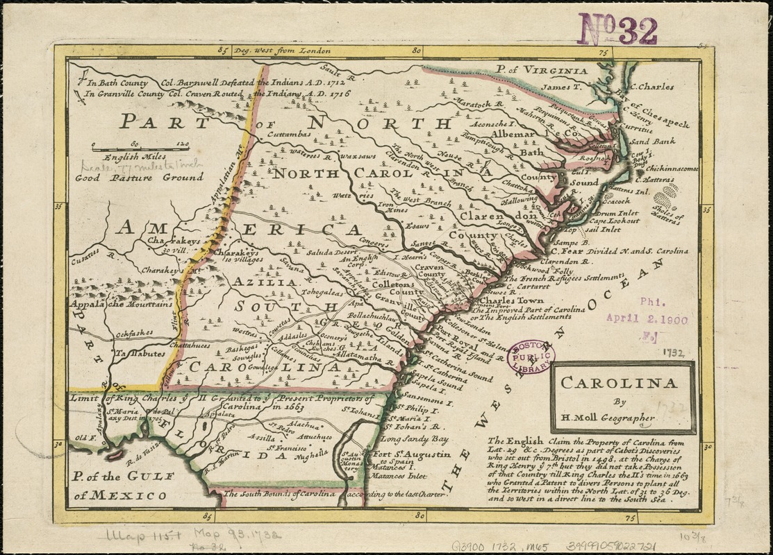
Carolina
Carolina
×
Item Information
Title:
Carolina
Creator:
Moll, Herman, d. 1732
Name on Item:
by H. Moll, geographer.
Date:
[1732?]
Format:
Maps/Atlases
Location:
Boston Public Library
Norman B. Leventhal Map Center
Collection (local):
Norman B. Leventhal Map Center Collection
Subjects:
North Carolina--Maps--Early works to 1800
South Carolina--Maps--Early works to 1800
Places:
North Carolina
South Carolina
Extent:
1 map ; 19 x 27 cm.
Permalink:
https://ark.digitalcommonwealth.org/ark:/50959/6t053q48k
Terms of Use:
No known copyright restrictions.
No known restrictions on use.
Publisher:
London? : s.n.
Scale:
Scale [ca. 1:5,500,000]
Language:
English
Notes:
Relief shown pictorially.
Prime meridian: London.
Includes text.
Identifier:
06_01_006318
Call #:
G3900 1732 .M65
Barcode:
39999059022721
show more...
View MODS XML
More Like This
An accurate map of North and South Carolina with their Indian ...
Carte des deux Carolines et de la Géorgie
Chart of the coast of America from Cape Hateras to Cape Roman
Chart of the coast of America from Cape Hateras to Cape Roman
Find More Like This >>
Tools
Share
Facebook
Pinterest
X
Reddit
Tumblr
Email
Copy link
Add to Folder
Questions/Comments
Cite This Item
IIIF Manifest
Downloads
Primary (full resolution, uncompressed)
(TIF, 53.8 MB)
Large (full resolution)
(JPEG, 4.52 MB)
Medium
(JPEG, 396 KB)
GeoTIFF (georeferenced)
(TIF, 57.6 MB)