Skip to search
Skip to main content
Digital Commonwealth
Sign Up / Log In
Search for
Search
Search
Search
Basic
Advanced
Explore
Map
Collections
Institutions
Formats
For Educators
Primary Source Sets
Lesson Plans
Using Primary Sources
Searching Digital Commonwealth
For Institutions
Join Digital Commonwealth
Conferences, Trainings, & Events
How to Contribute Collections
Digitization Services
Board & Committees
Frequently Asked Questions
About
About Digital Commonwealth
News & Announcements
Copyright & Terms of Use
Harmful Content Statement
Partners
API
Contact Us
Boston Public Library
Norman B. Leventhal Map Center Collection
/
American Revolutionary War-Era Maps (Collection of Distinction)
Sketch of the country illustrating the late engagement in Long Island
Sketch of the country illustrating the late engagement in Long Island
×
Item Information
Title:
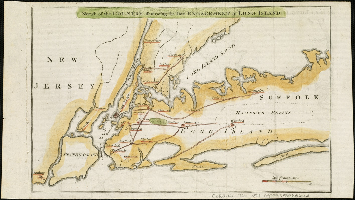
Sketch of the country illustrating the late engagement in Long Island
Date:
[1776]
Format:
Maps/Atlases
Location:
Boston Public Library
Norman B. Leventhal Map Center
Collection (local):
Norman B. Leventhal Map Center Collection
Subjects:
Long Island, Battle of, New York, N.Y., 1776--Maps--Early works to 1800
Long Island (N.Y.)--History--Revolution, 1775-1783--Maps--Early works to 1800
Long Island (N.Y.)--Maps--Early works to 1800
New York Region--Maps--Early works to 1800
Places:
Long Island
(island)
Extent:
1 map ; 20 x 32 cm.
Permalink:
https://ark.digitalcommonwealth.org/ark:/50959/6t053q42x
Terms of Use:
No known copyright restrictions.
No known restrictions on use.
Publisher:
London : s.n.
Scale:
Scale [ca. 1:316,800]
Language:
English
Notes:
Covers New York region from Amboy, N.J., on the west and south to western Suffolk County, N.Y., on the east, and Westchester County, N.Y., on the north.
Depths shown by soundings.
From: The gentleman's magazine, v. 46, Oct. 1776.
Notes (date):
This date is inferred.
Identifier:
06_01_006314
Call #:
G3802.L6 1776 .S54
Barcode:
39999059022663
LCCN:
gm 71002206
show more...
View MODS XML
More Like This
A plan of New York Island, with part of Long Island, Staten Island ...
A plan of New York Island, with part of Long Island, Staten Island ...
The seat of action, between the British and American forces : or ...
Chart of the entrance of Hudson's River, from Sandy Hook to New ...
Find More Like This >>
Tools
Share
Facebook
Pinterest
X
Reddit
Tumblr
Email
Copy link
Add to Folder
Questions/Comments
Cite This Item
IIIF Manifest
Downloads
Primary (full resolution, uncompressed)
(TIF, 31.3 MB)
Large (full resolution)
(JPEG, 2.63 MB)
Medium
(JPEG, 375 KB)