Skip to search
Skip to main content
Digital Commonwealth
Sign Up / Log In
Search for
Search
Search
Search
Basic
Advanced
Explore
Map
Collections
Institutions
Formats
For Educators
Primary Source Sets
Lesson Plans
Using Primary Sources
Searching Digital Commonwealth
For Institutions
Join Digital Commonwealth
Conferences, Trainings, & Events
How to Contribute Collections
Digitization Services
Board & Committees
Frequently Asked Questions
About
About Digital Commonwealth
News & Announcements
Copyright & Terms of Use
Harmful Content Statement
Partners
API
Contact Us
Boston Public Library
Norman B. Leventhal Map Center Collection
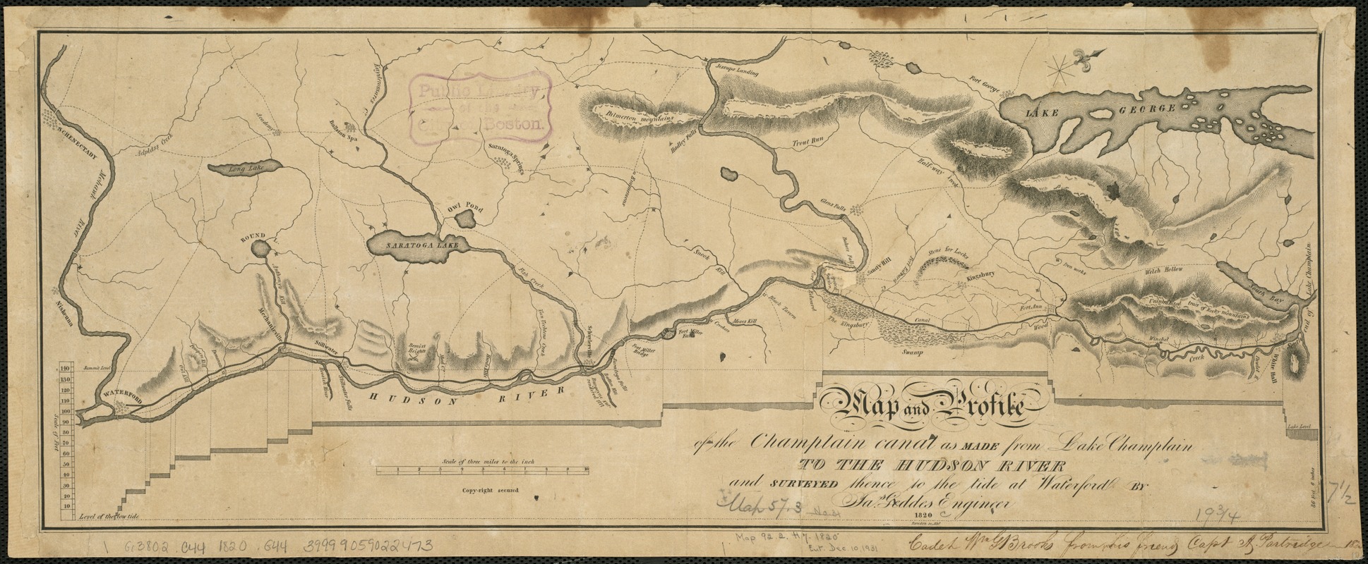
Map and profile of the Champlain Canal as made from Lake Champlain to the Hudson River and surveyed thence to the tide at Waterford
Map and profile of the Champlain Canal as made from Lake Champlain to the Hudson River and surveyed thence to the tide at Waterford
×
Item Information
Title:
Map and profile of the Champlain Canal as made from Lake Champlain to the Hudson River and surveyed thence to the tide at Waterford
Creator:
Geddes, James, 1763-1838
Name on Item:
by Jas. Geddes, engineer ; Rawdon, sc.
Date:
1820
Format:
Maps/Atlases
Location:
Boston Public Library
Norman B. Leventhal Map Center
Collection (local):
Norman B. Leventhal Map Center Collection
Subjects:
Champlain Canal (N.Y.)--Maps
Champlain Canal (N.Y.)--Altitudes--Charts, diagrams, etc
Hudson River Valley (N.Y. and N.J.)--Maps
Places:
Champlain Canal
Hudson River
Extent:
1 map ; 20 x 50 cm.
Permalink:
https://ark.digitalcommonwealth.org/ark:/50959/6t053q126
Terms of Use:
No known copyright restrictions.
No known restrictions on use.
Publisher:
Albany, N.Y.? : [Jas. Geddes?]
Scale:
Scale [1:190,080]. "Scale of 3 miles to the in." Vertical scale [ca. 1:720].
Language:
English
Notes:
Relief shown by hachures.
Oriented with north to the upper right.
Identifier:
06_01_004058
Call #:
G3802.C44 1820 .G44
Barcode:
39999059022473
show more...
View MODS XML
More Like This
Map of the State of New York
Fowler's new map of the Hudson River : with a description of the ...
International map of the world on the scale 1:1,000,000
A new map of the Hudson River : the post roads between N. York & ...
Find More Like This >>
Tools
Share
Facebook
Pinterest
X
Reddit
Tumblr
Email
Copy link
Add to Folder
Questions/Comments
Cite This Item
IIIF Manifest
Downloads
Primary (full resolution, uncompressed)
(TIF, 98.1 MB)
Large (full resolution)
(JPEG, 8.24 MB)
Medium
(JPEG, 532 KB)